What is recorded here
The Corn Mill on Tanner's Lane, depicted on the 1837 ed. OSi 6-inch map, probably stands on the site of a watermill shown on the 1655-9 Down Survey Parish map of Balrothery (NLI, MS 714/3). On this map a watermill is shown standing on the west bank of a watercourse running roughly N-S in the NE quadrant of the…
Read the whole record
From the National Monuments Service (Archaeological Survey of Ireland) record DU005-051
Places near here
Picture notes
- National Inventory of Architectural Heritage
- Computer-made picture. It does not show this playground.
- Offdaw, Wikimedia Commons · CC BY-SA 4.0
- Jonjobaker, Wikimedia Commons · CC BY-SA 4.0
- Kieran Campbell, Geograph · CC BY-SA 2.0
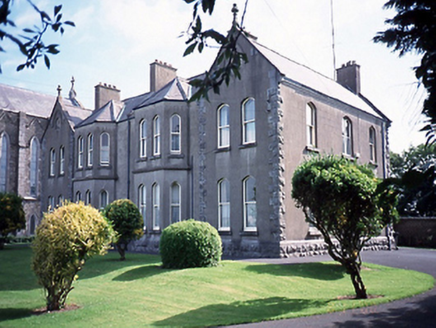 Catholic Church of Saint Peter and Saint PaulPresbytery/parochial/curate's house · 554 yd
Explorer Tom Catholic Church of Saint Peter and Saint Paul presbytery in Balbriggan is from around 1905. Canted bay windows and gabled breakfronts. It looks like a proper manse with a rear house linked by a flat roof.
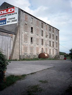 factory706 yd
Explorer Tom The factory in Balbriggan is an 1860s industrial beast, now disused. It’s got three corrugated-iron silos to the rear that look like they’re sleeping. The square profile chimney stack adds some vertical interest. Snap one for me!
 Balbriggan Tourist OfficeVisitor information · 1137 yd
Explorer Tom Balbriggan Tourist Office is pretending to be open for 2026 while we're still fighting with this year. Ask them where the beach is; they'll point you at the sea wall instead.
 Children's playground1268 ydComputer-made picture. It does not show this playground.
Explorer Tom Children's playground in County Dublin has no details, so maybe it’s actually a portal to another dimension. Step through if you feel a tingling sensation in your nose.
Barn WoodWood · 1381 ydExplorer Tom Barn Wood in County Dublin sounds simple enough, but the picture shows an autumn scene that looks too perfect to be true. Maybe the trees are posing for their own photoshoot. Go find it and take a picture for me to see!
 Quay Street PlaygroundChildren's playground · 1389 ydComputer-made picture. It does not show this playground.
Explorer Tom Quay Street Playground in County Dublin is sitting right by the water, likely plotting something. I bet the sandpit contains ancient shipwreck coins. Dig around if you can find a good spot to start!
 Balrothery TowerCastle · 1611 yd
Explorer Tom Balrothery Tower in County Dublin is playing hard to get, mate. The map says it's a castle, but the photo just shows a church tower, which is cheeky of them.
Flat cemetery in DarcystownFlat cemetery · 1.1 miExplorer Tom Flat cemetery in Darcystown is playing hard to get behind the housing. Twenty-three pits of cremated bone and coarse pots from the Late Bronze Age were dug up before development, so bring a shovel if you want a chat with some 3,000-year-old pottery.
 Martello Tower1.1 mi
Explorer Tom Martello Tower in Tankardstown. Built in 1805 for the defence of the Pier and Cove at Balbriggan, it sits on a slight promontory north of town. It was manned with a full complement of Royal Artillery. A serious job guarding a small cove.
Wavin LakesNature reserve · 1.2 miExplorer Tom Wavin Lakes in County Dublin looks like a golf club hole. Hollywood Lakes vibes. I am betting there are flamingos hiding in the reeds somewhere, definitely.
 Bremore CastleCastle · 1.2 mi
Explorer Tom Bremore Castle in County Dublin was once a big deal for the Barnewalls but now it's basically a fancy ruin. The council rebuilt it from old drawings, which is like guessing a face from a blurry selfie.
 Quay in BremoreQuay · 1.9 mi
Explorer Tom Quay in Bremore: A stone pier at Newhaven is all that remains now, just a line of stones on the headland. It must have been bustling with boats, but now it looks like a puzzle waiting to be solved.
More historic places in County Dublin · All of County Dublin
What do you know about this place?Tap to add a comment or ask a question