What is recorded here
From the National Monuments Service (Archaeological Survey of Ireland) record LI049-086008
Places near here
Photo credits
- National Inventory of Architectural Heritage
- Colin Park, Geograph · CC BY-SA 2.0
- Hywel Williams, Geograph · Creative Commons Attribution-ShareAlike 2.0
- kevin higgins, Geograph · CC BY-SA 2.0
 bridge456 yd
Explorer Tom Bridge in Galbally has excellent craftsmanship, but it’s too busy showing off its voussoirs for small talk. I bet it posts photos of itself every morning just to humble the modern concrete ones. Perfect detour when you want a stone that knows its worth.
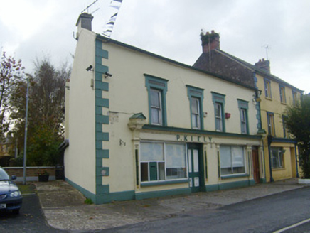 P. KielyShop/retail outlet · 605 ydDarby's Bed Walk LoopWalking route · 1.6 miDuntryleague - hachuredCastle, ringwork · 2.4 mi
Explorer Tom Duntryleague Castle is hiding its face behind the grass. Rumour has it a cow tried to buy the place with three pears and a promise of milk. Perfect spot to practise your best tour-guide voice.
Site of Dungrot CastleCastle, unclassified · 2.4 mi SlievenamuckMountain / peak · 2.9 mi
 Ladys WellHoly well · 3.0 mi
Explorer Tom Ladys Well in Ballylanders in Limerick is in a churchyard with statues of Our Lady, looking very dignified. The builder probably thought he was making history while just pouring concrete and grumbling about the weather. Bring your nan, she'll know more than me.
Carn (site of)Cairn, burial cairn · 3.4 miExplorer Tom Carn in Ballylooby used to be a hill but got levelled by a quarry for some reason. A hero nobody remembers saved it from total obscurity, probably with a really bad pun. Stop the car, it's worth the hazard lights.
Giant's Rock - Rock of AglaishNamed rock · 3.4 mi CarrignabinniaMountain / peak · 3.7 mi
 Grave YardGraveyard · 3.9 mi
 Lough CurraWalking route · 4.3 mi
More historic places in County Limerick · All of County Limerick

What do you know about this place?Tap to add a comment or ask a question