What is recorded here
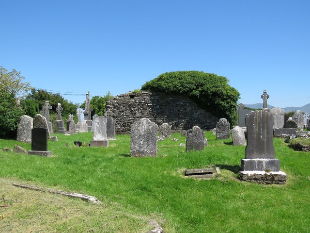
The medieval church ruins (LI049-086002-) of Ballingarry stands in centre of graveyard which consists of a rectangular-shaped area (approx. dims. 30m N-S x 52m E-W) enclosed by post-1700 stone wall. St Peter's and St. Paul's Well (LI049-108----) lies 125m to NE, enclosure (LI049-125----) 135m to WNW.
From the National Monuments Service (Archaeological Survey of Ireland) record LI049-107002
The monument record does not grant public access. Check the route and ask the landowner before entering private land.
- What survives
- Recorded monument
Places near here
St. Peters & St. Pauls WellHoly well · 176 yd Saint Patrick's Catholic ChurchChurch/chapel · 629 ydbridge1005 ydSlievereaghMountain / peak · 1.3 miLadys WellHoly well · 1.3 miSaint Patrick's WellSpring · 2.0 miEdmund's WellSpring · 2.4 miBallinvreena LoopVisitor information · 2.7 miDarby's Bed Walk LoopWalking route · 2.8 miCastle (in ruins)Castle, tower house · 3.5 miParadise HillMountain / peak · 4.8 miCastle OliverCastle · 6.0 mi
 Saint Patrick's Catholic ChurchChurch/chapel · 629 yd
 bridge1005 yd
 SlievereaghMountain / peak · 1.3 mi
 Ladys WellHoly well · 1.3 miSaint Patrick's WellSpring · 2.0 miEdmund's WellSpring · 2.4 miBallinvreena LoopVisitor information · 2.7 miDarby's Bed Walk LoopWalking route · 2.8 mi
 Castle (in ruins)Castle, tower house · 3.5 mi
 Paradise HillMountain / peak · 4.8 mi
.jpg/250px-Castle_Oliver_(1).jpg "Photo: Mygodfrey at en.wikipedia, Wikimedia Commons · CC BY-SA 3.0") Castle OliverCastle · 6.0 mi
Castle OliverCastle · 6.0 miPictures: Colin Park, Geograph · Creative Commons Attribution-ShareAlike 2.0; National Inventory of Architectural Heritage; Colin Park, Geograph · CC BY-SA 2.0; Hywel Williams, Geograph · Creative Commons Attribution-ShareAlike 2.0; Mike Searle, Wikimedia Commons · CC BY-SA 2.0; N Chadwick, Geograph · CC BY-SA 2.0; Mygodfrey at en.wikipedia, Wikimedia Commons · CC BY-SA 3.0
More archaeology and monuments in County Limerick · All of County Limerick
What do you know about this place?