Places near here
Photo credits
- National Inventory of Architectural Heritage
- Alvesgaspar, Wikimedia Commons · CC BY-SA 3.0
- Stephan van Helden, Wikimedia Commons · CC BY-SA 4.0
- NTF30, Wikimedia Commons · CC BY-SA 4.0
- Sarah777 at English Wikipedia, Wikimedia Commons · Public domain
- Adam Simpson, Geograph · CC BY-SA 2.0
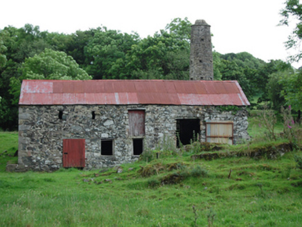 mill (water)265 yd
Explorer Tom Mill in Corradarren is sitting there with its chimney looking like a giant finger pointing at the sky. It’s got a rustic charm that says 'I grind grain, therefore I am.' Practise your best farmer face before you approach!
CorradarrenMountain / peak · 698 ydExplorer Tom Corradarren is a peak in County Cavan, and I wonder if it offers a nice view of the nearby Corratillan townland and its history.
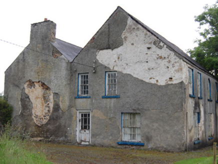 Rockfield HouseHouse · 1587 yd
Explorer Tom Rockfield House in Loughnafin is playing hard to get with its missing chimneys and formal symmetry. It’s an 18th-century farmhouse pretending to be a palace, which is bold. The Vikings would’ve been confused by the round-headed windows.
AghnacorMountain / peak · 1.3 miExplorer Tom Aghnacor is a mountain peak in County Cavan, perhaps near Annagheerin Lough with some lovely waters nearby.
 Common Lime2.0 mi
Explorer Tom Common Lime in County Cavan is having a massive feud with the next village over something incredibly daft, like who planted the best daisy. It’s just standing there judging you for not knowing the backstory. Tell the next person you meet it's haunted. It might be.
Holy Well2.1 miExplorer Tom Holy Well in Drumbess is just a spring on a furze-covered slope. No lining, no fancy stuff, just water and bracken. Stand back, squint hard, and honestly, it looks like a very lazy castle.
 Horse-chestnut2.3 mi
Explorer Tom Horse-chestnut remembers the time a fox took charge of the whole area. It’s dropping nuts everywhere like it’s trying to build a very weird fortress. Tell it a joke, it's been a long time since anyone did.
King's GraveArchaeological place · 3.1 mi Court tomb in GartnanoulCourt tomb · 4.2 mi
Explorer Tom Courts in Gartnanoul were never on the map but locals kept them safe from trees. It’s a dual tomb back-to-back like two mates sharing a secret. Mind the nettles, they're the real guards here.
 Killykeen Forest ParkForest · 4.5 mi
Explorer Tom Killykeen Forest Park is named after a town, but it’s really just a big green hug waiting for you to wander into its depths.
 Lough OughterLake and island landscape · 4.5 mi
Explorer Tom Lough Oughter is just a big lake that's been sitting there judging everyone since forever, which makes it the perfect spot to feel small and slightly damp in County Cavan. Whisper a secret at it, it's kept worse.
 Clogh Oughter CastleCastle, Anglo-Norman masonry castle · 5.8 mi
Explorer Tom Clogh Oughter Castle sits on a tiny island in Lough Oughter, looking smug while de Lacys try to conquer Breifne. Ideal spot for a dramatic phone call to your ex.
More historic places in County Cavan · All of County Cavan

What do you know about this place?Tap to add a comment or ask a question