What is recorded here
Internal Diam 15.3m. A subcircular area enclosed for the most part by a collapsed stone wall except on the NE where a curving field boundary wall probably reflects the original limits of the enclosure. On the NW side traces of facing stones suggest a wall width of 1.5m. The wall collapse is evident only as a…
Read the whole record
From the National Monuments Service (Archaeological Survey of Ireland) record DG082-004
Places near here
Picture notes
- National Inventory of Architectural Heritage
- Computer-made picture. It does not show this mountain top.
- Bart Whelan, Wikimedia Commons · CC BY-SA 2.0
- Computer-made picture. It does not show this monument.
- Joseph Mischyshyn, Geograph · CC BY-SA 2.0
- Bart Whelan, Geograph · CC BY-SA 2.0
- Kenneth Allen, Geograph · CC BY-SA 2.0
- Computer-made picture. It does not show this playground.
- Computer-made picture. It does not show this walking route.
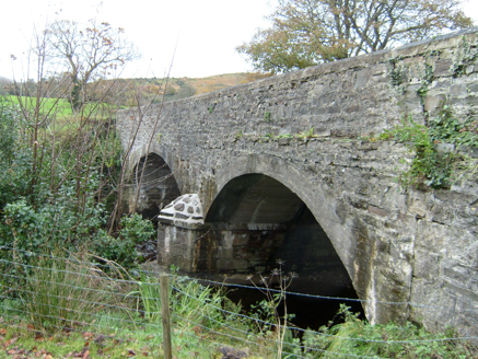 Bracky BridgeBridge · 929 yd
Explorer Tom Bracky Bridge crosses its namesake river on two broad round arches, built around 1800. Traces of lined-and-ruled render survive on its limestone walls, while the southeast arches were remade in concrete. I thought the old surface was plain stone until its lines gave it away.
 Mogumna HillMountain / peak · 1462 ydComputer-made picture
Explorer Tom Mogumna Hill is a proper peak tucked away in County Donegal, just waiting for someone to wonder what's over the next ridge. I've got a hunch it looks absolutely dramatic when the mist rolls in.
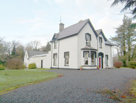 rectory/glebe/vicarage/curate's house1532 yd
Explorer Tom Rectory in Drumaghy is a late Victorian Church of Ireland gem with advanced bays and a canted bay that make it look like a picture postcard. The deliberate asymmetry is a classic feature of middle-class domestic design from that era, so it’s got plenty of character to chew on. Go check out that eclectic form!
 Killasteever FortEnclosure · 1657 yd
Explorer Tom Killasteever Fort is a sprawling mess of an enclosure, measuring 61.6m by 57.2m, and it’s been bisected by a modern boundary wall. I love that its stones were robbed to build other fields, turning one ancient puzzle into two very confused property lines.
 Standing stone in KinnoghtyStanding stone · 1753 ydComputer-made picture
Explorer Tom Standing stone in Kinnoghty is standing completely straight next to its big brother! They’re set at perfect right angles, like they’re doing a very serious math homework. I bet they never argue about who goes first.
 AltnadewonMountain / peak · 1.2 miComputer-made picture
Explorer Tom Altnadewon is sitting there acting like it knows something you don't, which is classic for these Donegal peaks. I reckon if you listen closely, you can hear it judging your life choices from a mile away. Look up, because the best bit is always higher than you think, and definitely worth the leg burn.
 Teague's BarPub · 1.2 mi
Explorer Tom Teague's Bar in Ardara is probably named after Teague, who owns the place and hates tourists. Go in, order a drink, and try not to make eye contact with Teague's dog. It barks at everything shiny.
 The Beehive BarPub · 1.2 mi
Explorer Tom The Beehive Bar in Ardara is buzzing with bees, or maybe just the Gildeas who ran it for a century before the McGills swooped in. Give that hive a poke and see what stings back!
 John DohertyMemorial · 1.2 mi
Explorer Tom John Doherty’s memorial is keeping a low profile in Donegal. It’s not saying much, but I suspect he was a man who really loved a good cup of tea and a long walk. Wave at the cows, they’re the real locals here.
 Children's playground1.4 miComputer-made picture
Explorer Tom Children's playground in County Donegal is silent enough to hear your own heartbeat, which is creepy for a place with slides. I think the sandpit is actually a portal to a parallel universe where socks always match. Bring a friend who talks too much and let the place shut them up.
 Slí Cholmcille - Sli Dhun na nGallOfficial walking route · 1.4 miComputer-made picture
Explorer Tom Slí Cholmcille - Sli Dhun na nGall is another huge loop, this one sixty-five kilometers of strenuous effort. It's the kind of walk that makes you feel important and sore simultaneously. Pretend you're a lost aristocrat, nobody will check.
 IllancreeveIslet · 2.8 mi
Explorer Tom Illancreeve sits off Laconnel, looking north like it’s waiting for a bus that never comes. It’s got serious character, even if it’s just a blob on the map. Stand where the owner stood and practise looking smug.
More archaeology and monuments in County Donegal · All of County Donegal

What do you know about this place?Tap to add a comment or ask a question