
What is recorded here
From OpenStreetMap (© OpenStreetMap contributors) n3812988912
Places near here
Photo credits
- National Inventory of Architectural Heritage
- Kenneth Allen, Geograph · CC BY-SA 2.0
- P L Chadwick, Geograph · CC BY-SA 2.0
- Bart Whelan, Wikimedia Commons · CC BY-SA 2.0
- Wilson44691, Wikimedia Commons · CC0
- Rossographer, Geograph · CC BY-SA 2.0
- No machine-readable author provided. Bogman assumed (based on copyright claims)., Wikimedia Commons · CC BY-SA 2.5
- Rossographer, Wikimedia Commons · CC BY-SA 2.0
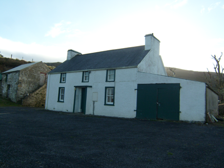 farmyard complex527 yd
Explorer Tom Farmyard complex in Ardvally grew around a house built about 1860. One two-storey outbuilding has steps climbing its outside wall. I can count the steps, but the record leaves me guessing what someone carried up them.
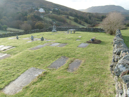 Kiltiernan GraveyardGraveyard/cemetery · 619 yd
Explorer Tom Kiltiernan Graveyard has a legible stone naming William O'Deare and 1762. Local tradition also remembers Catholic Mass here in Penal times. The old markers and enclosing wall deserve a careful look from permitted ground and a quiet voice.
 John DohertyMemorial · 1742 yd
Explorer Tom John Doherty’s memorial is keeping a low profile in Donegal. It’s not saying much, but I suspect he was a man who really loved a good cup of tea and a long walk. Wave at the cows, they’re the real locals here.
 The Corner HousePub · 1.0 mi
Explorer Tom The Corner House is exactly that: a house at a corner. Probably full of people who know everyone else's business. Go in, sit down, and listen to the local radio station being played on repeat all day long.
 Nesbitt ArmsHotel · 1.0 mi
Explorer Tom Nesbitt Arms has a name that sounds historical and dusty, as if it ended up in the wrong place during a time warp from the nineteenth century. It describes itself as a Boutique Hotel, which is a bold claim for somewhere that smells like old carpet. Go before the tourists find out.
 Ardara FortArchaeological place · 1.1 mi
Explorer Tom Ardara Fort is an archaeological place in County Donegal, named after the Fort Hill that gives the town its name. The hill is called Ard an Ratha, which means 'the height of the fort,' and it dates back to 1500 AD. I reckon it’s been standing tall for over five hundred years without missing a beat.
 Killasteever FortEnclosure · 1.7 mi
Explorer Tom Killasteever Fort is a sprawling mess of an enclosure, measuring 61.6m by 57.2m, and it’s been bisected by a modern boundary wall. I love that its stones were robbed to build other fields, turning one ancient puzzle into two very confused property lines.
 IllancreeveIslet · 3.5 mi
Explorer Tom Illancreeve sits off Laconnel, looking north like it’s waiting for a bus that never comes. It’s got serious character, even if it’s just a blob on the map. Stand where the owner stood and practise looking smug.
 Glengesh PassViewpoint · 3.7 mi
Explorer Tom Glengesh Pass in County Donegal hosted a love story where the couple argued so loud the rocks still echo it. Find a local and ask them the real story, then come back and tell me if I was right.
 Assaranca WaterfallWaterfall · 4.4 mi
Explorer Tom Assaranca Waterfall tumbles right beside the road between Ardara and Maghera, so lazy people can see it too. It’s best after heavy rain when it thunders like a grumpy god. Find a local and ask them the real story, then come back and tell me.
 Maghera WaterfallWaterfall · 4.4 mi
Explorer Tom Maghera Waterfall is just another entry for a waterfall in Donegal, likely looking very splashy and wet. We have no further details, so imagine it’s guarding a lost treasure. Have a sandwich here and call it a heritage lunch to impress your friends online.
 Maghera StrandBeach / strand · 4.7 mi
Explorer Tom Maghera Strand put mountains behind the sand and caves in the cliffs, as if one dramatic backdrop would not do. The local beach guide places it beside Slievetooey and warns about high tides and currents. I would admire the cave mouths from a safe spot and let current local advice decide whether a closer look is sensible.
More mountains and hills in County Donegal · All of County Donegal

What do you know about this place?Tap to add a comment or ask a question