
Places near here
Photo credits
- National Inventory of Architectural Heritage
- Bart Whelan, Wikimedia Commons · CC BY-SA 2.0
- Wilson44691, Wikimedia Commons · CC0
- Joseph Mischyshyn, Geograph · CC BY-SA 2.0
- Bart Whelan, Geograph · CC BY-SA 2.0
- Kenneth Allen, Geograph · CC BY-SA 2.0
- louise price, Wikimedia Commons · CC BY-SA 2.0
- No machine-readable author provided. Bogman assumed (based on copyright claims)., Wikimedia Commons · CC BY-SA 2.5
- Rossographer, Geograph · CC BY-SA 2.0
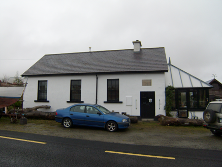 Scoil Náisiúnta Mín na Bhealaigh [Meenavally National School]School · 1.3 mi
Explorer Tom Scoil Náisiúnta Mín na Bhealaigh [Meenavally National School] has a plaque from 1899 that spells 'Meenavally' all wrong. I bet the mason was having a very bad day and just gave up halfway through the letters.
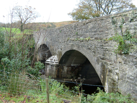 Bracky BridgeBridge · 1.7 mi
Explorer Tom Bracky Bridge crosses its namesake river on two broad round arches, built around 1800. Traces of lined-and-ruled render survive on its limestone walls, while the southeast arches were remade in concrete. I thought the old surface was plain stone until its lines gave it away.
 Killasteever FortEnclosure · 1.8 mi
Explorer Tom Killasteever Fort is a sprawling mess of an enclosure, measuring 61.6m by 57.2m, and it’s been bisected by a modern boundary wall. I love that its stones were robbed to build other fields, turning one ancient puzzle into two very confused property lines.
 Glengesh PassViewpoint · 2.4 mi
Explorer Tom Glengesh Pass in County Donegal hosted a love story where the couple argued so loud the rocks still echo it. Find a local and ask them the real story, then come back and tell me if I was right.
 Teague's BarPub · 2.4 mi
Explorer Tom Teague's Bar in Ardara is probably named after Teague, who owns the place and hates tourists. Go in, order a drink, and try not to make eye contact with Teague's dog. It barks at everything shiny.
 The Beehive BarPub · 2.4 mi
Explorer Tom The Beehive Bar in Ardara is buzzing with bees, or maybe just the Gildeas who ran it for a century before the McGills swooped in. Give that hive a poke and see what stings back!
 John DohertyMemorial · 2.4 mi
Explorer Tom John Doherty’s memorial is keeping a low profile in Donegal. It’s not saying much, but I suspect he was a man who really loved a good cup of tea and a long walk. Wave at the cows, they’re the real locals here.
 Ardara FortArchaeological place · 2.7 mi
Explorer Tom Ardara Fort is an archaeological place in County Donegal, named after the Fort Hill that gives the town its name. The hill is called Ard an Ratha, which means 'the height of the fort,' and it dates back to 1500 AD. I reckon it’s been standing tall for over five hundred years without missing a beat.
 Balbane HillMountain / peak · 3.0 mi
Explorer Tom Balbane Hill has a photo of itself that looks like it's posing for a magazine. I bet the oldest stone there is judging your hiking boots right now. Spot the oldest stone and give it a name.
 IllancreeveIslet · 3.4 mi
Explorer Tom Illancreeve sits off Laconnel, looking north like it’s waiting for a bus that never comes. It’s got serious character, even if it’s just a blob on the map. Stand where the owner stood and practise looking smug.
 Maghera WaterfallWaterfall · 4.0 mi
Explorer Tom Maghera Waterfall is just another entry for a waterfall in Donegal, likely looking very splashy and wet. We have no further details, so imagine it’s guarding a lost treasure. Have a sandwich here and call it a heritage lunch to impress your friends online.
 Assaranca WaterfallWaterfall · 4.0 mi
Explorer Tom Assaranca Waterfall tumbles right beside the road between Ardara and Maghera, so lazy people can see it too. It’s best after heavy rain when it thunders like a grumpy god. Find a local and ask them the real story, then come back and tell me.
More mountains and hills in County Donegal · All of County Donegal

What do you know about this place?Tap to add a comment or ask a question