
What is recorded here
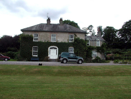
Detached four-bay single- and two-storey house, c.1820, retaining some original fenestration comprising two-bay single-storey central bay with half-dormer attic having single-bay two-storey gabled projecting end bay to right (east) with two-bay two-storey side elevation to east, and single-bay two-storey gabled end bay to left (west) with single-bay two-storey side elevation to west extending into three-bay two-storey return to north. Part refenestrated, c.1970. Pitched slate roofs (gabled to half-dormer attic window to central bay and to end bays) with clay ridge tiles, rendered chimney stacks, square rooflights, overhanging eaves to end bays, and cast-iron rainwater goods on band to eaves. Painted rendered walls with painted roughcast walls to rear (north) elevation. Square-headed window openings with rendered sills. 2/2 and 6/6 timber sash windows with some replacement timber casement windows, c.1970. Square-headed door opening with cut-stone step, rendered surround, and replacement glazed timber panelled door, c.1920. Square-headed door openings to side (east) elevation with two steps, rendered surrounds and replacement glazed timber panelled doors, c.1970. Set back from road in own grounds with gravel forecourt, and landscaped grounds to site. (ii) Attached seven-bay single-storey outbuilding with half-attic, c.1820, parallel to north with single-bay single-storey gabled end bay to right (east) having square-headed carriageway. Refenestrated, c.1970. Part reroofed, c.1995. Pitched slate roof (gabled to end bay) with section of replacement artificial slate, c.1995, clay ridge tiles, overhanging timber eaves to gable, and cast-iron rainwater goods on rendered eaves. Painted rendered walls. Square-headed window openings with rendered sills, and replacement timber casement windows, c.1970. Oculus window to gable to end bay with fittings not visible. Square-headed door openings with timber boarded and tongue-and-groove timber panelled doors. Square-headed carriageway with painted replacement corrugated-iron rolling double doors, c.1970. (iii) Detached five-bay single-storey stable building, c.1820, to north. Part refenestrated, c.1970, with one window opening remodelled. Pitched slate roof with clay ridge tiles, timber eaves to gables, and cast-iron rainwater goods on rendered eaves. Painted lime rendered walls over random rubble stone construction. Square-headed window opening remodelled, c.1970, with replacement concrete sill, c.1970, and replacement timber casement window, c.1970. Square-headed door openings with tongue-and-groove timber panelled half-doors. (iv) Gateway, c.1820, to east comprising pair of inscribed cut-stone circular piers with stringcourses, domed capping, and wrought iron double gates.
An appealing, middle-size house that forms an important element of the architectural heritage of the locality. The complex massing of the house, together with the various gables that articulate the skyline, enhance the architectural quality of the composition. The house retains most of its original form and early fabric, although the replacement of some of the fittings to the openings with inappropriate modern articles has compromised some of the historic character of the piece. The survival of a range of attendant outbuildings augments the group and setting qualities of the site, while the gateway presents an attractive feature fronting directly on to the streetscape.
From the Buildings of Ireland (National Inventory of Architectural Heritage) record 22901502
This does not grant access. Most recorded buildings are privately owned; view them only from public ground unless the owner allows entry.
Places near here
Site of CastleCastle, unclassified · 52 ydMan-made underground passage in KilcomeraghMan-made underground passage · 160 ydChildrens Burial Ground (Disused)Children's burial ground · 172 yd RockmountHouse · 271 ydHistoric buildingOfficially recorded historic building · 717 ydMahon ValleyCliff · 2.5 miMahon FallsWaterfall · 2.7 miKnockaunapeebraMountain / peak · 2.8 miCoumshingaunMountain corrie and lake · 3.3 miCoumfeaMountain / peak · 3.6 miCastleCastle, tower house · 5.6 miBallydowane CoveBeach / strand · 6.6 mi
 RockmountHouse · 271 yd
 Historic buildingOfficially recorded historic building · 717 yd
 Mahon ValleyCliff · 2.5 mi
 Mahon FallsWaterfall · 2.7 mi
 KnockaunapeebraMountain / peak · 2.8 mi
 CoumshingaunMountain corrie and lake · 3.3 mi
 CoumfeaMountain / peak · 3.6 mi
 CastleCastle, tower house · 5.6 mi
 Ballydowane CoveBeach / strand · 6.6 mi
Pictures: National Inventory of Architectural Heritage; kevin higgins, Geograph · CC BY-SA 2.0; Rwxrwxrwx at English Wikipedia, Wikimedia Commons · Public domain; Kevin O'Brien 13, Wikimedia Commons · CC BY-SA 4.0; Colin Park, Geograph · CC BY-SA 2.0; ethics girl, Geograph · CC BY-SA 2.0
More historic places in County Waterford · All of County Waterford
What do you know about this place?