
Places near here
Photo credits
- Warren Buckley, Geograph · CC BY-SA 2.0
- Colin Park, Wikimedia Commons · CC BY-SA 2.0
- dennis white, Wikimedia Commons · CC BY-SA 3.0
- National Inventory of Architectural Heritage
- Zairon, Wikimedia Commons · CC BY 4.0
- Graham Horn, Geograph · Creative Commons Attribution-ShareAlike 2.0
- Grainne Toomey, Wikimedia Commons · CC BY-SA 4.0
- Colin Park, Geograph · CC BY-SA 2.0
- Warren Buckley, Wikimedia Commons · CC BY-SA 2.0
- Charles W Glynn, Wikimedia Commons · CC BY-SA 2.0
 Beal PointHeadland · 1.6 mi
 KnockanoreMountain / peak · 2.4 mi
 Bromore CliffsCliff · 2.5 mi
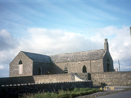 Doon Catholic ChurchChurch/chapel · 3.1 mi
Explorer Tom Doon Catholic Church would write on its dating profile: 'T-shaped, closed since 1972, but still got that bellcote charm.' Built in 1830, it’s partly dismantled and looks like a puzzle missing several pieces. It probably thinks being abandoned is a lifestyle choice rather than an accident. Bring a flask of something warm and a story to swap.
 Nuns' BeachBeach / strand · 3.6 mi
 Kilcredaun BatteryBattery · 3.6 mi
Explorer Tom Kilcredaun Battery in Moyarta is a Napoleonic defence tower from 1814 that’s now disused but still looking sharp with its dressed limestone walls. It’s got a segmental blind arch over the door that used to accommodate a drawbridge, so picture that in your head. Stop the car, it’s worth the hazard lights.
 Ballybunion Cliff PathWalking route · 3.7 mi
Explorer Tom The Ballybunion Cliff Path is where Vikings got hopelessly lost looking for their boat. The cliffs have caves that whisper secrets to the waves below. Bring a friend who talks too much and let the place shut them up.
 Ladies' BeachBeach / strand · 3.9 mi
 CastleCastle, tower house · 3.9 mi
Explorer Tom Ballybunnion Castle is just one stubborn wall standing on a cliff, probably because the map makers got drunk and drew the rest of it in the wrong county entirely. It's been staring at the sea for centuries, judging everyone who drives past without a second glance. If it rains, blame me.
 Carrigaholt CastleCastle · 4.4 mi
Explorer Tom Carrigaholt Castle caused such a huge argument in the parish that they still can't agree on whether it was a fortress or just a very fancy storage unit. It’s sitting there in County Clare while everyone debates its true purpose over pints of stout. Take a mate and argue about what it was for.
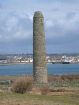 Scattery IslandIsland · 5.7 mi
Explorer Tom Scattery Island is in a bitter feud with the rain because they keep washing away its ancient round tower's dignity. It’s got a grudge about the weather that could last another five hundred years easily. Bring a jacket, it's never as warm as I promise.
 CLogaus or Round TowerRound tower · 5.9 mi
Explorer Tom Scattery Island’s round tower would say in a job interview that it’s reliable, punctual, and has never once needed a ladder to get anywhere important in its life. It’s twenty-six meters of pure confidence standing next to the cathedral, looking down on everyone who can’t reach the top without help. Go in good boots and better humour.
More archaeology and monuments in County Kerry · All of County Kerry

What do you know about this place?Tap to add a comment or ask a question