
Places near here
Photo credits
- National Inventory of Architectural Heritage
- Richard Webb, Geograph · CC BY-SA 2.0
- Ian Paterson, Wikimedia Commons · CC BY-SA 2.0
- Robert Bone, Wikimedia Commons · CC BY-SA 2.0
- Kenneth Allen, Wikimedia Commons · CC BY-SA 2.0
- Kenneth Allen, Geograph · CC BY-SA 2.0
- louise price, Wikimedia Commons · CC BY-SA 2.0
- D Gore, Geograph · CC BY-SA 2.0
 kiln2.5 mi
Explorer Tom Kiln in Falgarrow is a former lime kiln from the first half of the nineteenth century, surviving in relatively good condition with local rubble stone masonry. It’s modest but well-built and tied to an individual farm holding in the area. Go see if you can find any old lime residue!
 Gaugin MountainMountain / peak · 2.7 mi
Explorer Tom Gaugin Mountain stands at 595 meters on the northern fringe of the Bluestacks, guarding a cairn and a tattered football flag. It looks like it has been waiting since the 2012 All Ireland victory for someone to replace that rag with something less prone to shredding in the wind.
 Catholic Church of the Holy FamilyChurch/chapel · 3.1 mi
Explorer Tom Catholic Church of the Holy Family dates to 1906 and has a four-petal shape set inside a circle above its porch. The stained glass can have its turn too, but that tiny blank shape keeps stealing my attention. It is the church's quietest decoration.
 ScraigsMountain / peak · 3.2 mi
Explorer Tom Scraigs is a mountain / peak in County Donegal hiding a treasure that is definitely just an old biscuit tin. Legend says it’s full of gold, but I’m sure it’s actually stale digestive biscuits and regret. Still worth checking out if you’re feeling a bit nostalgic for snacks. Get a photo with it before it gets a better agent.
 Giant's Grave Megalithic TombMegalithic tomb · 3.5 mi
Explorer Tom Giant's Grave Megalithic Tomb lies deep in boggy ground between Aghla and Scraigs. The recorded gallery was five metres long, with six stones on each side. A slab across one end might not have been part of its original roof. That uncertainty is more interesting than pretending the wet ground offers an easy look inside.
 Stone cairn, LougherrigPublicly named cairn · 4.8 mi
Explorer Tom Stone cairn, Lougherrig is a simple name for what might be one of the oldest quiet spots in County Donegal. There’s no date attached to it, which means it could be as old as time itself or just a very stubborn pile. I’d like to know if it ever gets tired of being a landmark.
 Teach Tábhairne an RileánPub · 5.0 mi
Explorer Tom Teach Tábhairne an Rileán in County Donegal has a mouthful of a name. Say it three times fast for me and tell me how you feel! Bring your worst joke, the place has heard worse.
 Disert GraveyardGraveyard · 6.8 mi
Explorer Tom Disert Graveyard is a D-shaped pocket inside two larger enclosures, with at least 34 low uninscribed grave markers noted across its centre. The account also records a striking custom: people took soil from near the altar because it was reputed to drive rats from houses. I'd keep that as a belief people held, not a promise from the place.
 Inishkeel Graveyard near GlentiesGraveyard · 7.1 mi
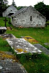
Explorer Tom Inishkeel Graveyard near Glenties was rectangular in the older survey, but its south side sat on part of a roughly circular rise. Some of that rise lay beyond the west wall, about fifty metres across. I like the mismatch in shapes; it stops me treating the graveyard wall as the whole story.
 Ard na Mona WoodOfficial walking route · 7.5 mi
Explorer Tom Ard na Mona Wood had a serious falling out with the next village over whose turn it was to take out the recycling. It’s been sulking in the shadows of Banagher Hill ever since, looking very dignified about the whole mess. Ring your granny and tell her where you are.
 Kennedy's Bar and RestaurantRestaurant · 7.7 mi
Explorer Tom Kennedy's Bar and Restaurant is definitely hiding a secret menu involving only cabbage and regret. I bet the barman knows more about ghosts than he does about cocktails, so keep your ears peeled for whispers while you eat.
 St. Connell's Museum and Heritage CentreMuseum · 7.7 mi
Explorer Tom St. Connell's Museum and Heritage Centre lets me go from an old courtroom to the cells below, then into stories of the workhouse and Donegal railways. That is a lot of Glenties history packed into one building. I would leave the cells to the displays and keep my own visit on the friendly side of the door.
More mountains and hills in County Donegal · All of County Donegal

What do you know about this place?Tap to add a comment or ask a question