What is recorded here
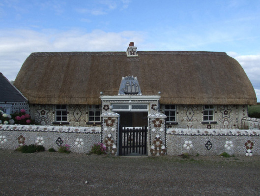
Detached five-bay single-storey lobby entry thatched farmhouse, extant 1840, on a rectangular plan centred on single-bay single-storey flat-roofed projecting porch. Reroofed, 2006. Chicken wire-covered replacement hipped or hipped gabled oat thatch roof with rope twist-topped exposed hazel lattice stretchers to ridge having exposed scallops, shell-encrusted rendered central chimney stack having shell-encrusted rendered capping supporting terracotta pots, and exposed hazel stretchers to eaves having exposed scallops. Shell-encrusted rendered battered walls with shell-encrusted strips to corners. Square-headed central door opening into farmhouse. Square-headed flanking window openings with concrete sills, and shell-encrusted surrounds framing timber casement windows replacing two-over-two timber sash windows having part exposed sash boxes. Set back from line of road with shell-encrusted rendered piers to perimeter having ball finial-topped shell-encrusted shallow pyramidal capping supporting timber gate.
A farmhouse identified as an important component of the vernacular heritage of south County Wexford by such attributes as the rectilinear lobby entry plan form; the construction in unrefined local fieldstone displaying a battered silhouette with sections of "daub" or mud suggested by an entry in the "House and Building Return" Form of the National Census (NA 1901; NA 1911); the somewhat disproportionate bias of solid to void in the massing; and the high pitched roof showing an oat thatch finish replenished with the financial assistance of a grant (2006) from The Heritage Council. Having been well maintained, the form and massing survive intact together with substantial quantities of the original fabric, both to the exterior and to the interior, including eye-catching Folk Art-like shell work 'designed and crafted [by] KEVIN L. FFRENCH [1921-2003]'. Furthermore, adjacent outbuildings (----) continue to contribute positively to the group and setting values of a self-contained ensemble making a picturesque visual statement overlooking Ballyteige Bay.
From the Buildings of Ireland (National Inventory of Architectural Heritage) record 15704615
This does not grant access. Most recorded buildings are privately owned; view them only from public ground unless the owner allows entry.
Places near here
 handball alley91 yd
 Cullenstown StrandBeach / strand · 185 yd
 Windmill795 yd
 mill (wind)795 yd
 Blackhall StrandBeach / strand · 1.2 mi
 Keeragh IslandsIsland · 1.4 mi
 Coolhull CastleHouse, fortified house · 1.5 mi
 Danes Castle (in ruins)Castle, tower house · 2.4 mi
 Ballyteigue BurrowNature reserve · 3.4 mi
 Cull IslandIsland · 3.5 mi
 Grave YardGraveyard · 4.9 mi
 Tintern AbbeyBuilding misc · 5.1 mi
Pictures: Oliver Dixon, Geograph · CC BY-SA 2.0; National Inventory of Architectural Heritage; Pam Brophy, Wikimedia Commons · CC BY-SA 2.0; Mike Searle, Geograph · CC BY-SA 2.0; kevin higgins, Wikimedia Commons · CC BY-SA 2.0; kevin higgins, Geograph · CC BY-SA 2.0; cisko66, Wikimedia Commons · CC BY 3.0; Eirian Evans, Geograph · Creative Commons Attribution-ShareAlike 2.0
More historic places in County Wexford · All of County Wexford
What do you know about this place?