
What is recorded here
From OpenStreetMap (© OpenStreetMap contributors) n10292155030
Places near here
Picture notes
- Computer-made picture. It does not show this mountain top.
- kevin higgins, Wikimedia Commons · CC BY-SA 2.0
- Computer-made picture. It does not show this monument.
- National Inventory of Architectural Heritage
- Computer-made picture. It does not show this walking route.
- Tdr112, Wikimedia Commons · CC BY-SA 4.0
- Mooro1, Wikimedia Commons · CC BY-SA 4.0
- Wsiegmund, Wikimedia Commons · CC BY 2.5
- Computer-made picture. It does not show this playground.
 Ridge of CapardMountain / peak · 580 ydComputer-made picture
 BaunreaghcongMountain / peak · 1.2 mi
 Bullaun stone in BallyhuppahaneBullaun stone · 1.5 miComputer-made picture
Explorer Tom Bullaun stone in Ballyhuppahane is hiding in a plantation like it’s shy about its twelve rings. I met the matchmaker who worked there; she was terrible at her job. Toast it with a cup of tea and move on to the next one.
 Ritual siteRitual site, holy tree/bush · 1.9 miComputer-made picture
Explorer Tom Capard's ritual bush handles nosey neighbours by pretending to be a very boring hedge. It’s a hawthorn that marked a penal mass station before getting blown down in a storm. Give it a pat on the way past, it's had a long life.
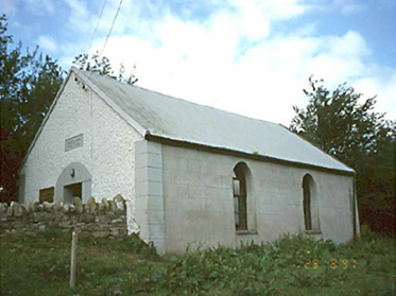 Ballyhuppahane Methodist ChurchChurch/chapel · 2.2 mi
Explorer Tom Ballyhuppahane Methodist Church in County Laois would tell its replacement that at least it had good manners. Dated 1848, it’s seen better decades and probably knows all the gossip. Give it a pat on the way past, it's had a long life.
 Glenbarrow EcoloopWalking route · 2.3 miComputer-made picture
 Slieve Bloom WayWalking route · 2.3 miComputer-made picture
 Monicknew BridgeBridge · 2.6 mi
Explorer Tom Monicknew Bridge used to be run by a matchmaker who paired off horses with each other. Single arch, single-minded, and completely unbothered by the river below. Bring a friend who talks too much and let the place shut them up.
Turrets (in Ruins)Bawn · 3.2 miExplorer Tom Turrets in Coolnamony Lower were invented by some local who thought everyone else was missing out on the fun. All that's left is one wall, which is a bit like a skeleton with no ribs. Tell it a joke, it's been a long time since anyone did.
 Slieve Bloom MountainsMountain range · 3.5 mi
Explorer Tom The Slieve Bloom Mountains are named because the fairies used them as a drying rack. Locals say the peaks actually glow blue when the wind blows right. Sit on a wall near it and pretend you're in a painting.
 Sitka Spruce3.8 mi
Explorer Tom Sitka Spruce in County Laois would tell Saint Patrick he was a tourist in his own country because of how tall it gets. St. Pat would probably just shrug and move on. Find a local and ask them the real story, then come back and tell me.
 Ballyfin PlaygroundChildren's playground · 3.8 miComputer-made picture
More mountains and hills in County Laois · All of County Laois

What do you know about this place?Tap to add a comment or ask a question