
What is recorded here
From the National Monuments Service (Archaeological Survey of Ireland) record ME028-008
Places near here
Photo credits
- Offdaw, Wikimedia Commons · CC BY-SA 4.0
- National Inventory of Architectural Heritage
- Maker not stated on source page, irisharchaeology.org
- Maker not stated on source page, www.pinterest.com
- Kieran Campbell, Geograph · CC BY-SA 2.0
- Rfoconnor at English Wikipedia, Wikimedia Commons · Public domain
- Kieran Campbell, Wikimedia Commons · CC BY-SA 2.0
- Maker not stated on source page, www.dreamstime.com
 bridge954 yd
Explorer Tom Bridge in Corballis replaced an iron one from 1859, probably because the neighbours argued about its colour. It…
 public house1068 yd
Explorer Tom Public house in Ninch has an entrance so fancy it makes the pub feel like a museum. I bet there’s a hidden treasure…
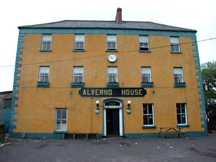 Alverno HotelHotel · 1149 yd
Explorer Tom Alverno Hotel in Ninch would win a county fair for best display, probably by just standing there and looking grand. It…
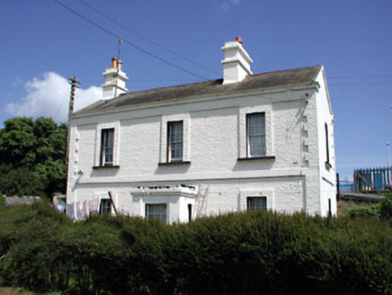 Laytown Railway StationStation master's house · 1208 yd
Explorer Tom Laytown Railway Station in Ninch saw the whole parish argue about whether it was actually a house or a very fancy shed.…
 water pump1368 yd
Explorer Tom Water pump in Ninch is standing there with an acorn finial that looks like it’s about to pop off and hit someone on the…
 Fairy fort / earthen ringfort in Irishtown (duleek Upper By., Moorechurch Par.)Fairy fort / earthen ringfort · 1.1 mi
Explorer Tom Enclosure in Irishtown is circular with one entrance gap, which feels like an insult to the other directions. It's…
 Graveyard in BallygarthGraveyard · 1.2 mi
Explorer Tom Graveyard in Ballygarth is just a family burial ground for the Peppards since the 1650s, which makes it sound like a…
 Church in BallygarthChurch · 1.2 mi
Explorer Tom Church in Ballygarth sits on a rise above the River Nanny, which is just a stream pretending to be bigger. It’s not…
 Ballygarth CastleCastle · 1.3 mi
Explorer Tom Ballygarth Castle is stuck in a furious dispute with the fairies over who gets to park their little chariots first.…
 CrossCross, Wayside cross · 1.3 mi
Explorer Tom Cross in Sarsfieldstown is stuck in a garden like an awkward uncle at a wedding. It’s got a Pietá that looks deeply…
 Battle of JulianstownBattle · 1.7 mi
Explorer Tom Battle of Julianstown in County Meath is having a massive go at winning the county fair prize for 'Most Dramatic Mud…
 Mapped cemeteryCemetery · 2.5 mi
Explorer Tom Mapped Cemetery insists that the shortcut through the middle is actually the longest way around if you take the scenic…
More archaeology and monuments in County Meath · All of County Meath

What do you know about this place?Tap to add a comment or ask a question