Places near here
Photo credits
- National Inventory of Architectural Heritage
- Jeanne dArc at English Wikipedia, Wikimedia Commons · CC BY-SA 3.0
- kevin higgins, Geograph · CC BY-SA 2.0
- Oliver Dixon, Wikimedia Commons · CC BY-SA 2.0
- Rev William Falkiner (Life time: d 1910), Wikimedia Commons · Public domain
- Mike Searle, Geograph · CC BY-SA 2.0
- Bridget Neville, Wikimedia Commons · CC BY-SA 4.0
Explorer Tom Fairy fort or earthen ringfort in Tyfarnham is having a feud with the next village about whether their fence intersects its bank properly, which is honestly quite daft given it's barely there. Toast it with a cup of tea and move on to the next spot before you get stuck.
RahanduffFairy fort / earthen ringfort · 1190 ydExplorer Tom Rahanduff in Down is sitting next to a modern quarry that is actively stealing its thunder. Imagine what it would write on its dating profile: 'Ancient, rugged, slightly eroded, looking for someone who doesn't dig up my past.' It has a great view of the industrial chaos happening right beside it. Ideal spot for a dramatic phone call.
 Church of Saint John the Baptist (Stonehall)Church/chapel · 1366 yd
Explorer Tom Stonehall’s Saint John the Baptist church would be the guest at the wedding who arrives fashionably late and looks slightly disheveled. It’s in ruinous condition but still has that early nineteenth-century charm going for it. Don’t let the ivy scare you off; it’s just being dramatic.
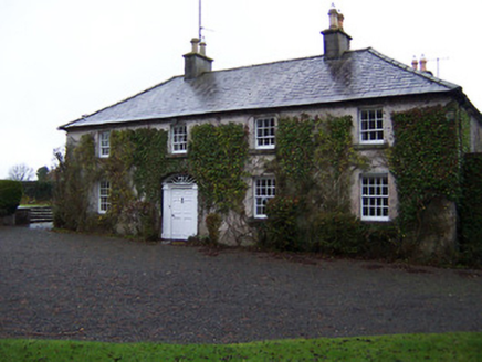 StonehallHouse · 1378 yd
Explorer Tom Stonehall has a retirement plan involving becoming completely one with the ivy until nobody can tell where the house ends and the garden begins. It wants to be soft, green, and unbothered by all the fuss of modern life, preferring to nap in the shade while the world rushes past. If you hear rustling that sounds like snoring, it’s just Stonehall dreaming about its plant-covered future.
Bridge Memorial (Kenna)Memorial · 1.9 miExplorer Tom Bridge Memorial (Kenna) is where the Vikings got so lost looking for the exit that they ended up building their own little camp instead. They left after three days, mostly because the weather turned nasty and the supplies ran out completely. Ten minutes here and you'll have a yarn for the pub.
Scragh Bog Nature ReserveNature reserve · 2.0 miExplorer Tom Scragh Bog Nature Reserve was designed by a mother-in-law who really wanted you to feel uncomfortable about your boots. It’s all about balance and not slipping into the mud forever. It's the kind of place that makes a dull Tuesday interesting.
 KnockeyonMountain / peak · 2.8 mi
Explorer Tom Knockeyon hates visitors who wear bright yellow because it reminds it of the time a pigeon got stuck in its moss. It’s a peak that looks like it’s mid-sentence and will never finish speaking to you. Take a mate and argue about what it was for.
 Church IslandIsland · 2.8 mi
Explorer Tom Church Island in County Westmeath would tell a teenager that the 1800s were basically just slow Wi-Fi and worse fashion. The old stones are still judging your outfit choices from back then. Go at sunset and thank me later.
 Children of Lir: Lough DerravaraghLegend location · 2.8 mi
Explorer Tom Children of Lir: Lough Derravaragh starts with four children becoming swans because Aoife could not bear sharing the attention. That is not a family argument I want to referee. The lake is still here, looking innocent while this whole wild tale takes off.
 Mortimer's CastleArchaeological place · 2.9 mi
Explorer Tom Mortimer’s Castle in County Westmeath is locked in a bitter feud with the rain, insisting it looks majestic even when it’s actually just a soggy hillside pretending to have walls. The name sounds fancy but the reality is mostly mud and stubbornness. Stick around for the light changing, it's a show.
 Carrick CastleCastle · 3.6 mi
Explorer Tom Carrick Castle is haunted by the memory of a fiddler who played all night until his fingers gave up, leaving behind nothing but the echo of a terrible jig. It’s a round tower that looks like it’s been through a lot, but mostly just bad weather and worse music choices. Go on a wet day, it suits the mood.
 Saint Brigid's WellSpring · 4.1 mi
Explorer Tom Saint Brigid's Well has an escape plan involving a cart of hay and a very fast horse named Brenda. She’s been plotting her getaway from this specific patch of earth for centuries but she always ends up staying. Pretend you're a lost aristocrat, nobody will check.
More historic places in County Westmeath · All of County Westmeath

What do you know about this place?Tap to add a comment or ask a question