
Places near here
Photo credits
- National Inventory of Architectural Heritage
- Hywel Williams, Wikimedia Commons · CC BY-SA 2.0
- Sole Origami, Wikimedia Commons · CC BY-SA 4.0
- Frederick Dean, Geograph · CC BY-SA 2.0
- Corkonian2013, Wikimedia Commons · CC BY-SA 3.0
- Ceoil at English Wikipedia, Wikimedia Commons · CC BY-SA 3.0
- Jo and Steve Turner, Geograph · CC BY-SA 2.0
- Jim Woodward-Nutt, Wikimedia Commons · CC BY-SA 2.0
- Jonathan Thacker, Wikimedia Commons · CC BY-SA 2.0
- Joebater at English Wikipedia, Wikimedia Commons · CC BY-SA 3.0
- Donald MacDonald, Geograph · CC BY-SA 2.0
 St Eolan's Roman Catholic ChurchChurch/chapel · 1.2 mi
Explorer Tom St Eolan's Roman Catholic Church in Rylane, County Cork broke the mold after Vatican II with its light design. I bet it smells like expensive incense and secret gossip. Hear the echo of my name inside for me!
 St Olans WellHoly well · 1.8 mi
Explorer Tom St Olans Well is surrounded by stone and votive offerings, making it look a bit like an ancient jewelry box. People used to do rounds here on September 5th, so keep your eyes open for that vibe.
 St John the Baptist ChurchOfficially recorded historic building · 2.3 mi
Explorer Tom St John the Baptist Church in Ballyvongane dressed up like a palace when it’s actually a barn, which is either brave or delusional. Have a look at those pinnacles!
 Mullinhassig WaterfallWaterfall · 2.5 mi
 Mullinhassig WoodWood · 2.6 mi
 Carrigagulla Stone CircleArchaeological place · 3.7 mi
Explorer Tom Carrigagulla Stone Circle in County Cork is north of Ballinagree and looks like it’s waiting for someone to start dancing. I bet they used to party hard here. Check if the circle is complete or if one stone ran off.
 Carrigadrohid CastleHeritage attraction · 4.4 mi
 Carrigadrohid Castle (in Ruins)Castle, tower house · 4.4 mi
Explorer Tom Carrigadrohid Castle is standing in water because someone decided to build a dam nearby. It's basically an island now, which is very dramatic. The MacCarthys built this back in the fifteenth century, so it's seen some stuff!
 Bealick MillVisitor attraction · 5.7 mi
 MusheraMountain / peak · 5.8 mi
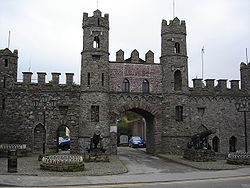 Battle of MacroomBattle · 6.1 mi
Explorer Tom Battle of Macroom in County Cork had a fake royal visit that nobody can disprove to this day. Ideal for a moody photo you'll pretend wasn't posed, just for the 'gram.
 Macroom Castle (in Ruins)Castle, tower house · 6.3 mi
Explorer Tom Macroom Castle was demolished to build a technical school, which is the kind of insult only Cork can pull off. It used to have two square towers that were just too much hassle. Bring a camera and your most suspicious face for the school.
More archaeology and monuments in County Cork · All of County Cork

What do you know about this place?Tap to add a comment or ask a question