
Places near here
Photo credits
- Kieran Campbell, Wikimedia Commons · CC BY-SA 2.0
- JP, Geograph · CC BY-SA 2.0
- National Inventory of Architectural Heritage
- Heywood Sumner, Wikimedia Commons · Public domain
- Malene Thyssen, Wikimedia Commons · CC BY-SA 3.0
- Kieran Campbell, Geograph · CC BY-SA 2.0
- Willow, Wikimedia Commons · CC BY 2.5
- Tjp finn, Wikimedia Commons · CC BY-SA 4.0
- David Brossard, Wikimedia Commons · CC BY-SA 2.0
- John M, Wikimedia Commons · CC BY-SA 2.0
- Sitomon, Wikimedia Commons · Public domain
 CrossCross, Wayside cross · 1.2 mi
Explorer Tom Cross in Balrath nearly became famous when a tourist mistook it for a giant lollipop. It has moved so often it’s developed a habit of checking over its shoulder for the next relocation order. Pretend it's yours and plan the housewarming.
 Balrath Post OfficePost office · 1.2 mi
Explorer Tom Balrath Post Office looks like it was built for a king, not just to sell stamps. A cow once tried to buy it with a udder, but the postman wasn't convinced. Bring curiosity, leave with a stamp and a new friend.
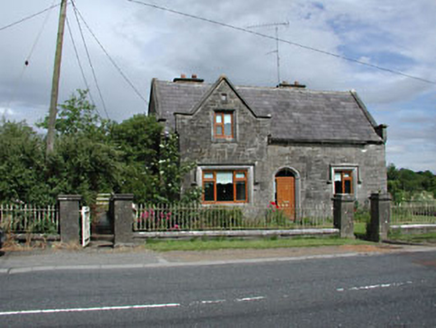 Stone LodgeRic barracks · 1.2 mi
Explorer Tom Stone Lodge in Balrath is locked in a bitter feud with the rain, and losing badly. It stands next to a post office that looks just as confused about its Tudor Gothic roots. Make up your own legend and I'll swear it's true.
 BarrowBarrow, unclassified · 1.2 mi
Explorer Tom Barrow in Gaulstown is a circular mound on a slope, about fourteen metres across and nearly three metres high, which is roughly the height of a very confused giraffe. It has no distinguishing features, so it’s just sitting there waiting for someone to point at it and say 'that's the one'. It’s probably holding a fake family tree in its pocket, mostly made up of cousins. Ideal stop for a big yawn.
 European Beech1.4 mi
Explorer Tom European Beech in County Meath has a fiddler who played there all night, leaving the leaves trembling with the memory of it. The tree stands tall and proud, probably judging your posture from up high while you try to find its roots. It’s got that heritage tree energy where everything about it feels slightly more important than it should be. Have a chat with it, nobody's watching.
 Athcarne CastleCastle, tower house · 2.0 mi
Explorer Tom Athcarne Castle is feuding with the next village over because they stole its shadow last Tuesday. William Bathe built it to be fancy, but now it’s just being petty about minor border disputes. Bring someone who'll believe anything, like me.
 European ash2.5 mi
Explorer Tom European ash in County Meath makes map makers look like amateurs because nobody can seem to find the right path to it. It’s basically hiding from its own fame. Best seen with a hangover and a sausage roll.
 CastleCastle, tower house · 3.7 mi
Explorer Tom Castle in Monktown is locked in an eternal feud with the rain, and honestly, it’s losing badly. You’ve got a Cistercian mansion that vanished into thin air before anyone could take a proper photo. It’s basically the ghost of a property listing nobody wanted to buy. Stand on the spot and imagine the gossip it's heard.
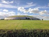 NewgrangeHeritage attraction · 3.8 mi
Explorer Tom You reckon you are punctual? Try keeping an appointment for five thousand years. Newgrange is older than Stonehenge, but it still knows how to make an entrance. At the winter solstice, sunrise reaches through a small roofbox above the doorway and lights the chamber at the end of a passage about 19 metres long. Imagine hauling roughly 200,000 tonnes of earth and stone into a mound, then arranging for the sun to make a punctual visit. That little roofbox has better timekeeping than me, and it has never owned a watch. The entrance stone weighs about five tonnes and carries carved spirals; elsewhere, some carvings were placed on faces that would be hidden under the finished structure. That is an extraordinary amount of work for an audience of almost nobody. Twelve standing stones remain from a possible circle of thirty-eight, and the bright quartz front you see today includes a twentieth century reconstruction that archaeologists still debate. The mound is a monument, not an open shortcut into a chamber, so follow the site's visitor arrangements for entry. I will be outside, trying to arrive on time for something for once.
 Oengus Óg: NewgrangeLegend location · 3.8 mi
Explorer Tom Oengus Óg: Newgrange gives this ancient monument a love story with a very odd ending: he finds Caer as a swan, becomes one himself and flies home with her. I was ready for a romantic walk; Oengus went straight for wings. Fair play to him.
 Brú na Bóinne Visitors CentreVisitor information · 3.9 mi
Explorer Tom Brú na Bóinne Visitors Centre in County Meath has very strong opinions on modern buildings, mostly that they’re too bright and not ancient enough. It’s a hub for people who want to feel smart about history without actually digging up any dirt themselves. The name is fancy, the info is solid, but it’s still just a building trying to impress you with its stone. Go now, before it gets famous
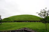 KnowthArchaeological place · 4.3 mi
Explorer Tom You see one mound? Give Knowth another minute to complicate your day. Knowth looks like one enormous grassy mound in the Boyne Valley until its stonework starts giving away the plot. The main monument, built around 3200 BC, holds two separate passages, one entering from the east and one from the west. Around its base stood 127 kerbstones, and excavators found more than 200 carved stones, including art hidden on faces that visitors would not normally have seen. If I could read every carved line, I would still let the builders keep a few secrets. That is quite a private gallery for a place already making a public impression. Centuries later people built a royal residence on top, using the old mound for a new kind of authority. Knowth is part of the Brú na Bóinne heritage complex, and visits are managed through the visitor arrangements there; check current booking and access before going. Study the carved spirals, but leave the ancient builders at least one secret they can keep.
More archaeology and monuments in County Meath · All of County Meath

What do you know about this place?Tap to add a comment or ask a question