Places near here
Photo credits
- Mike Searle, Geograph · CC BY-SA 2.0
- National Inventory of Architectural Heritage
- Mike Searle, Wikimedia Commons · CC BY-SA 2.0
- dougf, Geograph · CC BY-SA 2.0
- El Gringo ( talk ) ( Uploads ), Wikimedia Commons · CC BY-SA 3.0
- Gordon Hatton, Wikimedia Commons · CC BY-SA 2.0
- Neville Goodman, Geograph · CC BY-SA 2.0
 Fort RobertArchaeological place · 696 yd
Explorer Tom Fort Robert is actually a ruined house from 1788! Built by R.L. Connor. It’s all crumbling slates and history. Take a photo for me to see how much of that grand house is left.
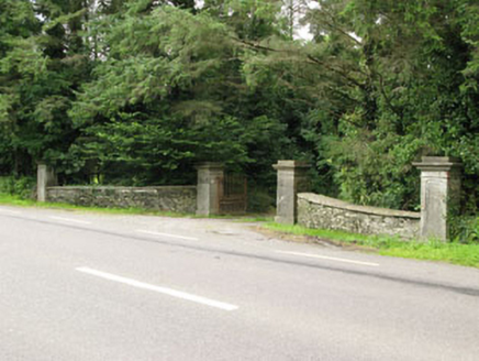 Carrigmore HouseGates/railings/walls · 1345 yd
Explorer Tom Carrigmore House has an entrance gateway that screams ‘look at me’ with its carved limestone details, probably because the house itself is too shy to speak up. It’s like a bouncer who knows all the VIPs but still checks IDs. Keep your eyes peeled for any aristocratic nonsense hiding behind those fancy carvings.
Irish National Forestry FoundationNature reserve · 1393 yd farmyard complex1.3 mi
Explorer Tom Farmyard complex in Phale Lower is sprawling around since 1880 with a farmhouse that looks like it’s seen better days. The outbuildings are huge for a farm, which suggests they were either very productive or just really into storage back then.
Castle RockNamed rock · 1.3 mi Cloigtheach (Round Tower)Round tower · 1.8 mi
Explorer Tom Cloigtheach in Sleenoge has a unique hexagonal base that makes it look like it was built by someone who really liked geometry. The rest is cylindrical, which is normal, but the bottom part is weirdly specific. Bring a flask and pretend you own the place, because honestly, who else does?
The GlenWood · 2.7 mi Tower (in Ruins)Bawn · 2.9 mi
Explorer Tom Tower in Ballynacarriga is just fragmentary bawn remains next to the main castle. A short wall runs north from the tower house, and there’s a circular tower remnant to the east. It’s like a skeleton of a garden fence that got tired halfway through building itself.
 Ballynacarriga CastleCastle, tower house · 2.9 mi
Explorer Tom Ballynacarriga Castle is a four-storey tower house overlooking the lough. It has a spiral stair, vaulted lobby, and murder hole. The top floor was used as a chapel later on. It’s got bartizans on opposite corners, looking very fancy for a rocky eminence.
 Kilmichael AmbushAmbush · 5.7 mi
Explorer Tom Kilmichael Ambush in County Cork is where the rabbits think the soldiers were just having a very aggressive game of hide-and-seek. Pretend you're a lost aristocrat, nobody will check your ID.
 Kilmichael Ambush SiteMonument · 5.7 mi
 Milane HillMountain / peak · 9.5 mi
More archaeology and monuments in County Cork · All of County Cork

What do you know about this place?Tap to add a comment or ask a question