What is recorded here
From the National Monuments Service (Archaeological Survey of Ireland) record SL012-078003
Places near here
Photo credits
- National Inventory of Architectural Heritage
- Michael Dibb, Geograph · CC BY-SA 2.0
- Colin Park, Geograph · CC BY-SA 2.0
- Paul Burns, Geograph · CC BY-SA 2.0
- Pampuco, Wikimedia Commons · CC BY-SA 4.0
- Willow, Wikimedia Commons · CC BY 2.5
Explorer Tom Hut site in Ballyfaris is having a massive identity crisis right now because it can't decide if it's square or round. It nearly went viral back in the day when some tourist mistook it for a fancy outdoor sauna, but the landowner shut that down fast. Visit, then text me what you think. I'll pretend to read it.
Enclosure in BallyfarisEnclosure · 291 ydExplorer Tom Enclosure in Ballyfaris is L-shaped because it gave up halfway through the circle and just decided that was fine. It nearly got famous for being a weirdly shaped pile of dirt on a low rise. Ideal spot for a dramatic phone call.
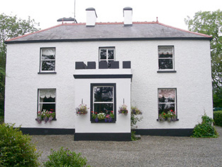 Fortlaurel HouseHouse · 1134 yd
Explorer Tom Fortlaurel House in Ardogelly would post on social media 'Just woke up, the winding driveway is giving me whiplash' because it’s so well-sited and pleasingly proportioned that it feels like a model home. It’s largely intact with extensive grounds that make you want to take a long walk. Snap a pic of those extensive grounds!
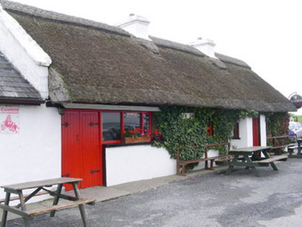 public house1.3 mi
Explorer Tom Aughris Public House is so remote and thatched that a fox once took charge and ordered rounds for everyone. It’s got this atmospheric interior that feels like time forgot to update it, which is actually quite charming in a weird way. Cheers from a respectful distance!
 Aughris BeachBeach / strand · 1.3 mi
Explorer Tom Aughris Beach is playing hide-and-seek with me, and I swear there's a secret tunnel straight to the pub if you know which rock to kiss. I've been staring at it for an hour and it hasn't blinked once. Bring curiosity, leave with a better story than mine.
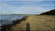 Dunmoran StrandBeach / strand · 1.7 mi
Explorer Tom Dunmoran Strand bragged about surviving a storm that flattened houses but left this place looking merely annoyed. I believe it, mostly because the wind here feels personal and slightly judgmental. Go before the tourists find out.
 Aughris HeadHeadland · 1.8 mi
Explorer Tom Aughris Head in County Sligo is a headland with strong opinions, particularly about what it would order at a chipper: extra gravy, no chips, just the vibe. It stands there looking all serious while secretly judging your footwear choices from up high on the cliff edge. Get there early and have it all to yourself.
CastleCastle, unclassified · 2.2 miExplorer Tom Castle in County Sligo has a dating profile that just says 'mysterious, slightly damp, no fixed address.' It’s another Boazio mystery, hiding in plain sight while we chase our tails around the county. I think it wants someone who can appreciate a good bit of nothingness without asking too many questions. Tell the next person you meet it's haunted. It might be.
Knockalongy North-East TopMountain / peak · 3.6 miExplorer Tom Knockalongy North-East Top in County Sligo is having a massive row with a nearby tree about who has better views. The tree is winning, by the way, because it's actually growing. Mind the nettles, they're the real guards here.
KnockalongyMountain / peak · 3.9 miExplorer Tom Knockalongy in County Sligo took about forty cups of tea to build, or so the legend goes. It’s a bit lumpy, like a biscuit that got stepped on, but charmingly so. Bring your nan, she'll know more than me.
 Sligo BayBay · 4.9 mi
Explorer Tom Sligo Bay in County Sligo would file a formal complaint with the council about all the litter floating on its surface. It’s got a grumpy personality, like a dog that only bites when you try to pet it too hard. Look for the ghost, then pretend you didn't see him.
 European ash5.2 mi
Explorer Tom European ash in County Sligo handles nosey neighbours by simply dropping a leaf directly on their heads every single time they look up. It’s a small act of defiance, but effective. Tell the kids it's a castle. Close enough.
More archaeology and monuments in County Sligo · All of County Sligo

What do you know about this place?Tap to add a comment or ask a question