What is recorded here
On a small island in extreme NW arm of Lough Corrib close to SE end of Gleann an Mháma. This 13th-C keep, now a Nat. Mon., was apparently built c. 1235 by Feidhlim, king of Connacht, as a replacement for an earlier castle built c. 1200 and burnt in 1233. Known locally as Caisleán na Circe, it originally belonged to…
Read the whole record
From the National Monuments Service (Archaeological Survey of Ireland) record GA039-020
Places near here
Photo credits
- Dr Wotsit, Wikimedia Commons · CC BY-SA 3.0
- National Inventory of Architectural Heritage
- Graham Horn, Wikimedia Commons / Geograph Britain and Ireland
- Maker not stated on source page, www.flickr.com
- Maker not stated on source page, en.wikipedia.org
- Michael Earnshaw, Wikimedia Commons · CC BY-SA 2.0
- Maker not stated on source page, nexusnewsfeed.com
 LackavreaMountain / peak · 1558 yd
Explorer Tom Lackavrea rises between Lough Corrib and the Maamturks, a Galway summit that seems to have hired every bog in Connemara…
 Doon HouseCountry house · 1.8 mi
Explorer Tom Doon House on Lough Corrib is a two-phase house that looks like it had a midlife crisis and added an extension. It…
 Western WayWalking route · 2.4 mi
Explorer Tom The Western Way sounds as if you just keep walking until somebody says you have reached the Atlantic. There is rather…
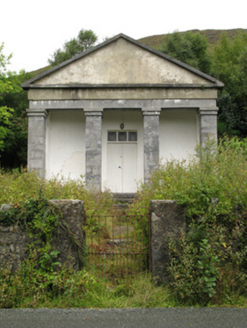 Maum CourthouseCourt house · 2.4 mi
Explorer Tom Maum Courthouse wants to resolve to stop judging everyone who walks past its temple front. It’s all dressed up in…
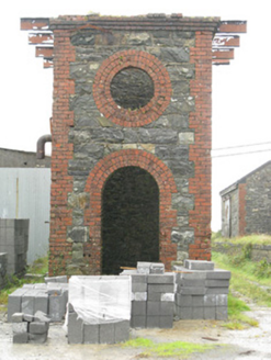 Maam Cross Railway StationRailway station · 2.6 mi
Explorer Tom Maam Cross Railway Station in Lurgan has a secret it would tell after a few pints: the cattle platform was for cows who…
 CorcogemoreMountain / peak · 2.8 mi
Explorer Tom Corcogemore sits at the southern end of Galway’s Maamturk Mountains, looking as if someone set a great stone beehive…
 bridge2.9 mi
Explorer Tom Bridge in Ardderrynagleragh has a ghost that's too lazy to haunt it properly, so it just stands there looking tired. It…
 Fairy fort / stone ringfort in An Mám ThiarFairy fort / stone ringfort · 3.2 mi
Explorer Tom Fairy fort / stone ringfort in An Mám Thiar is perched up high, watching the valley like it owes them money. After a…
 Breenane GraveyardGraveyard · 4.0 mi
Explorer Tom Breenane Graveyard is where Vikings supposedly got lost looking for it because they couldn't read the map or the trees.…
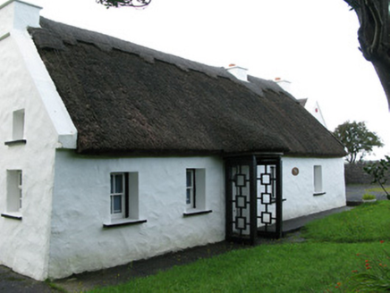 farm house4.8 mi
Explorer Tom Farm house in Letterfore has a curse on it that only affects people who don't wave at it properly. The thatched roofs…
 Binn MhórMountain / peak · 4.8 mi
Explorer Tom Binn Mhór means 'great peak', and its 661 metre shoulder rises above Mám Éan in Connemara's Maumturks. The hill has the…
 Fairy fort / earthen ringfort in Farravaun (moycullen By.)Fairy fort / earthen ringfort · 5.0 mi
Explorer Tom Fairy fort / earthen ringfort in Farravaun is sitting on a hilltop with a field wall hiding its scarp. Rumour says…
More castles and forts in County Galway · All of County Galway

What do you know about this place?Tap to add a comment or ask a question