What is recorded here
Castle, Castlepark is a limestone tower house in County Tipperary that once rose at least four storeys above the River Suir flood plain. By the second half of the 19th century, its chambers had been cut through into a gateway for Castlepark House, later Mantlehill House, turning a private stronghold into an entrance marker. The surviving vault, broken windows and rebuilt angles suggest a place repeatedly remade rather than lost, still holding the shape of the hands that changed it.
On a flat platform which falls away to E down to the flood plain of the River Suir, and Golden beyond the river, to E. Land rises to NW and slopes gradually to the S. A much modified tower house (ext. dims. 8.55m N-S; 5.9m E-W; wall T 1.2m) built of limestone rubble, roughly coursed. The castle is shown on the 1st (1840) ed. 6-inch OS map as a building on the grounds of Castlepark House, later renamed Mantlehill House. By the 2nd (1903-04) ed. the castle has been incorporated into a new entrance into the estate, so in the second half of the 19th century the tower house was altered to form a gateway, running E-W through the building. The tower house would originally have been at least four storeys high and there is a surviving stone vault over the first floor. A later section of stone vaulting was added onto the E end of the building and the E wall above the vault, including two pointed windows, appears to have been built when the tower house was converted into a gateway. The NE; SE and NW angles of the tower house have been rebuilt. The W end of the N wall has been refaced and a crack c. 0.3-0.4m wide in the middle of the N wall has been infilled. There are tie-stones projecting from the N end of the E wall up to a height of 2.7m. There is a buttress (H 1.85m; Wth 1.55m) at the E end of the S wall. A crudely rebuilt stairs (Wth 0.5m) rises in the N wall (T 1.3m) and is lit by two loops in the N wall and one at the N end of the E wall, all have crude stone surrounds and are badly spawled. At ground level there is a window embrasure at the W end of the S wall which is blocked up internally, the window is broken out. Roughly centrally placed in the S wall there is a round-headed opening for a doorway, with voussoirs forming the head. This doorway is blocked up and is not visible on the internal face. The first floor, which is beneath the vault, appears to have been entered from the stair via a doorway which has been partially blocked up to form a flat-headed window. This floor is likely to have been supported on a wooden floor carried on corbels. There appear to be the remains of three broken corbels on the internal face of the S wall, 2.4m above ground level. Only the eastern end of the second floor survives, entered from the stair at the N end of the E wall. There are two surviving embrasures, in the E (wall T 0.9m) and S wall (T 1.3m), both windows are broken out. At third-floor level only the NE angle and the E end of the N wall survives. A substantial wall (H c. 3.5m; Wth 1.5m; surviving L 0.45m), possibly a bawn wall (TS060-096001-), projects from the W end of the S wall.
Compiled by: Jean Farrelly
Date of upload: 11 December 2012
Built in the 15th or 16th century, Castlepark is remembered as a historic tower house associated with the Butler family, Earls of Ormond, reflecting the regional power and influence of this prominent noble lineage in medieval Ireland.
The monument record does not grant public access. Check the route and ask the landowner before entering private land.
- What survives
- Recorded monument
Places near here
 Bawn in CastleparkBawn · 8 yd
 worker's houseworker's house · 222 yd
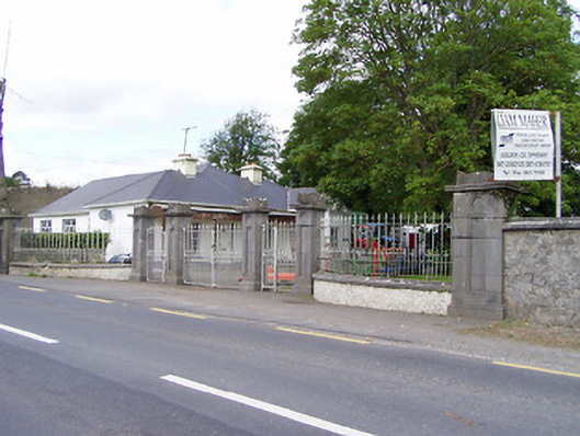 Mantlehill Housegates/railings/walls · 265 yd
 Castle in ruinsCastle, tower house · 461 yd
 GoldenSettlement cluster · 557 yd
 Enclosure in Springmount (relickmurray & Athassel Par.)Enclosure · 1259 yd
 Athassel PrioryHeritage attraction · 1.3 mi
 Hore AbbeyHeritage attraction · 4.1 mi
 European ashEuropean ash · 4.8 mi
 Dundrum Woods (Marl Bog)Forest · 4.9 mi
 The Maid of ErinMemorial · 7.5 mi
 SturrakeenMountain / peak · 8.0 mi