
What is recorded here
From OpenStreetMap (© OpenStreetMap contributors) n3805393055
Places near here
Photo credits
- National Inventory of Architectural Heritage
- Maker not stated on source page, www.travelingwithmj.com
- Kieran Evans, Wikimedia Commons · CC BY-SA 2.0
- Maker not stated on source page, commons.wikimedia.org
- louise price, Geograph · CC BY-SA 2.0
- Maker not stated on source page, www.youtube.com
- louise price, Wikimedia Commons · CC BY-SA 2.0
- Maker not stated on source page, ru.pinterest.com
- Maker not stated on source page, www.pinterest.com
 Catholic Church of the Holy FamilyChurch/chapel · 1.4 mi
Explorer Tom Catholic Church of the Holy Family dates to 1906 and has a four-petal shape set inside a circle above its porch. The…
 Fairy fort / earthen ringfort in An Tseanga Mheáin (tc An Ghrafaidh)Fairy fort / earthen ringfort · 1.7 mi
Explorer Tom Fairy fort / earthen ringfort in An Tseanga Mheáin has a bank standing over two metres high on the north side. It’s a…
 Lavagh MoreMountain / peak · 1.9 mi
Explorer Tom Lavagh More is involved in a feud with its neighbour over who owns the best view of the sunset, which has been going on…
 McDevitt's BridgeBridge · 2.1 mi
Explorer Tom McDevitt's Bridge, built c.1780, crosses the Owenea River on three segmental arches. Those cut-stone triangular…
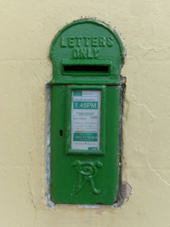 post box2.1 mi
Explorer Tom Post box in Greenans, installed c.1870, keeps its raised VR lettering firmly planted at the bottom. It sits right in…
 Graffy BridgeBridge · 2.3 mi
Explorer Tom Graffy Bridge was built around 1830 with two arches over the Stracashel River and an additional arch to the southwest.…
 Burial ground in Lag Na GaileadhBurial ground · 2.4 mi
Explorer Tom The Burial ground in Lag Na Gaileadh is a quiet oval mound on the bank of the Owenea river. It holds a stone slab with…
 CarnaweenMountain / peak · 2.9 mi
Explorer Tom Carnaween has Diarmuid Ó Duibhne hiding in its name, at least in the old local telling. There was even a…
 Fairy fort / ringfort in An Tard Donn,droim Chon CuaisFairy fort / ringfort · 3.4 mi
Explorer Tom Fairy fort / ringfort in An Tard Donn, Droim Chon Cuais came from local tradition on Crockmore hill. The survey found…
 Disert GraveyardGraveyard · 3.7 mi
Explorer Tom Disert Graveyard is a D-shaped pocket inside two larger enclosures, with at least 34 low uninscribed grave markers…
 Mapped graveyardGraveyard · 4.8 mi
Explorer Tom The most dramatic thing to ever happen at this unmapped graveyard was a pigeon landing on a headstone with suspicious…
 Moylederg IslandIslet · 6.1 mi
Explorer Tom Moylederg Island in Donegal is named after a guy who once slipped on a banana peel while trying to impress his date…
More mountains and hills in County Donegal · All of County Donegal

What do you know about this place?Tap to add a comment or ask a question