What is recorded here
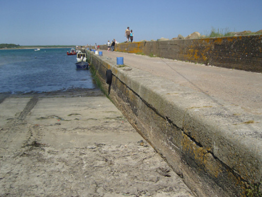
Pier, dated 1884-5, on a rectangular plan with mass concrete battered walls on submerged concrete block foundations having lichen-spotted cut-granite rounded coping supporting cast-iron mooring loops. Set extending into Saint George's Channel.
A pier erected by the Yorkshire-born contractor Thomas Ingham Dixon (----) of Donnybrook to designs by Robert Manning (1816-97), Chief Engineer to the Board of Public Works (appointed 1874; retired 1891; NA OPW 1884 8/61), representing an important component of the late nineteenth-century built heritage of south County Wexford with the engineering or technical dexterity of the composition confirmed by the pioneering mass concrete construction which, unlike the contemporary stone-faced Cheekpoint Pier (1884-6) by Manning and Dixon in neighbouring County Waterford (see 22901008), '[made] no effort to conceal the true nature of the concrete walls [as] there was no need to tie [it] back, structurally or aesthetically, to [a] pre-existing structure' (Shotton 2018 II, 1191). NOTE: A nearby pillar commemorates 'the brave men of Carnsore District who crewed the oared lifeboat from 1859-1897...under the coxswains of Patrick Cavanagh 1861-1891 and John Wall 1891-1897'.
From the Buildings of Ireland (National Inventory of Architectural Heritage) record 15705317
This does not grant access. Most recorded buildings are privately owned; view them only from public ground unless the owner allows entry.
Places near here
Photo credits
- Ojsyork, Wikimedia Commons · CC BY 4.0
- User Ali-oops on en.wikipedia, Wikimedia Commons · GFDL
- National Inventory of Architectural Heritage
 Lifeboat MemorialMemorial · 91 yd
 Carne BeachBeach / strand · 252 ydChurchtown Beach / The Sandy GripeBeach / strand · 529 yd
 CarnaghvillaFarm house · 669 ydSt. Margarets WellHoly well · 784 yd
 Teach SamhrainHouse · 821 ydShernock Hill/Knocks HillMountain / peak · 1170 ydNot indicatedEnclosure · 1220 ydCastleCastle, tower house · 1362 ydSite of CastleCastle, unclassified · 1558 ydThe Caravan RockNamed rock · 1.2 miThe Fairy Stone/RockNamed rock · 1.6 mi
More historic places in County Wexford · All of County Wexford
What do you know about this place?