What is recorded here
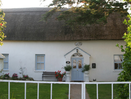
Detached four-bay single-storey lobby entry thatched house with dormer attic, extant 1840, on a rectangular plan off-centred on single-bay single-storey gabled windbreak. Vacant, 1901. Occupied, 1911. Renovated, 1996. Repaired, 2004, to accommodate continued occasional use. Replacement hipped water reed thatch roof on oat thatch base with chicken wire-covered exposed hazel lattice stretchers to raised ridge having exposed scallops, cement rendered off-central chimney stack having stepped capping supporting terracotta pots, and blind stretchers to eaves having blind scallops. Replacement rendered battered walls; rendered surface finish to rear (west) elevation centred on rendered battered buttress. Segmental-headed off-central door opening below "oeil-de-boeuf" with concealed dressings framing replacement glazed timber panelled door having fanlight. Square-headed window openings with concrete sills, and concealed dressings framing replacement timber casement windows replacing six-over-six (south) or two-over-two (north) timber sash windows having part exposed sash boxes. Set back from road in landscaped grounds with limewashed cylindrical piers to perimeter having conical capping.
A house identified as an integral component of the vernacular heritage of south County Wexford by such attributes as the rectilinear lobby entry plan form off-centred on a characteristic windbreak; the construction in unrefined local materials displaying a pronounced battered silhouette with sections of "daub" or mud suggested not only by a stabilising buttress but also by an entry in the "House and Buildings Return" Form of the National Census (NA 1901; NA 1911); the disproportionate bias of solid to void in the massing; and the high pitched roof originally showing an oat thatch finish: however, a comprehensive renovation programme involving the substitution of much of the original fabric has not had a beneficial impact on the external expression or integrity of a house making a picturesque visual statement in a sylvan street scene.
From the Buildings of Ireland (National Inventory of Architectural Heritage) record 15705320
This does not grant access. Most recorded buildings are privately owned; view them only from public ground unless the owner allows entry.
Places near here
Photo credits
- National Inventory of Architectural Heritage
- Ojsyork, Wikimedia Commons · CC BY 4.0
- User Ali-oops on en.wikipedia, Wikimedia Commons · GFDL
 mill (wind)250 yd
 CarnaghvillaFarm house · 268 ydCastleCastle, tower house · 552 ydChurchtown Beach / The Sandy GripeBeach / strand · 590 yd
 Lifeboat MemorialMemorial · 729 yd
 Carne BeachBeach / strand · 766 ydThe Long StoneArchaeological place · 1016 ydSite of CastleCastle, unclassified · 1130 ydSt. Margarets WellHoly well · 1263 ydThe Caravan RockNamed rock · 1373 ydShernock Hill/Knocks HillMountain / peak · 1.0 miThe CaamstoneNamed rock · 1.3 mi
More historic places in County Wexford · All of County Wexford
What do you know about this place?