Places near here
Photo credits
- National Inventory of Architectural Heritage
- Fractal Angel, Geograph · CC BY-SA 2.0
- dougf, Wikimedia Commons · CC BY-SA 2.0
- Mac McCarron, Geograph · CC BY-SA 2.0
- Mac McCarron, Geograph · Creative Commons Attribution-ShareAlike 2.0
- Rryswny, Wikimedia Commons · CC BY-SA 4.0
- Jsilke, Wikimedia Commons · CC BY-SA 4.0
- Ian Capper, Wikimedia Commons · CC BY-SA 2.0
- Ian Capper, Geograph · CC BY-SA 2.0
- Gareth James, Geograph · CC BY-SA 2.0
- N Chadwick, Geograph · CC BY-SA 2.0
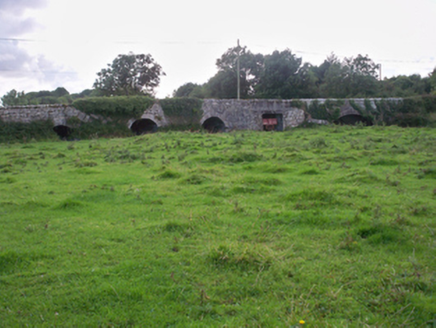 Dunkellin BridgeBridge · 1.5 mi
Explorer Tom Dunkellin Bridge swears it’s older than the river itself, which is wild. The varying arch styles add interest and a bit of mystery to the scene. If it rains, blame the small flood-relief arches for letting water in.
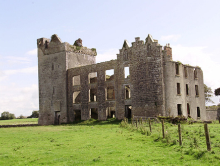 Castle TaylorCountry house · 1.5 mi
Explorer Tom Castle Taylor in Castletaylor South would describe the 1800s as “a bit rough on the knees, but great for drama”. It mixes medieval and Gothic styles like a fashion disaster that somehow works. Bring a jacket, the wind off the bay is no joke at all.
 Castle (in ruins)Castle, Anglo-Norman masonry castle · 2.5 mi
Explorer Tom Castle in Ardrahan North, County Galway is probably where the rabbits hold their council meetings every Tuesday night. They look very serious when they discuss the grass situation out there. Perfect spot to practise your best tour-guide voice.
 Round Tower (in ruins)Round tower · 2.6 mi
Explorer Tom Round Tower in Ardrahan North has been reduced to a few courses of limestone hidden under cemetery ground. Nobody knows where the top went, so I’m guessing it got promoted to heaven. Bring a pen pal, they’ll be jealous of its mystery.
 Site of Kilcolgan CastleCastle, tower house · 2.7 mi
Explorer Tom Site of Kilcolgan Castle in Kilcolgan is basically a ghost with a property dispute. The builder must have been thinking about lunch while laying the foundation, because it vanished before the paint dried. Bring curiosity, leave with a better story than mine.
 Grave YardGraveyard · 3.2 mi
Explorer Tom Graveyard in Stradbally South overlooks the Dunkellin estuary like a proud grandparent watching the waves roll in. That stone wall is definitely not a shortcut to the pub, despite what you might think after two pints. Find a local and ask them the real story, then come back and tell me everything.
 Drumacoo Monastic SiteHeritage attraction · 3.5 mi
Explorer Tom Drumacoo Monastic Site is complaining to the council that the tourists keep leaving their sandwiches on the grass and it’s getting a bit tired of all the mess. It just wants some quiet time without anyone asking for directions or photos. Tell the kids it's a castle. Close enough.
 Drumharsna CastleHeritage attraction · 3.6 mi
Explorer Tom Drumharsna Castle is absolutely convinced the postman is up to something dodgy every single morning when he walks past its ancient gates with his bag. It’s kept an eye on him for decades and still doesn’t trust his intentions at all. Ideal stop for a big stretch and a bigger yawn.
 InishcorraIslet · 7.8 mi
Explorer Tom Inishcorra was once ruled by a goat who ate all the maps and decided he knew where everything was, leading to total chaos. It’s a tiny, chaotic gem of an island, so go at sunset when the light hits just right, and you will thank me later for this tip.
 Tawin IslandIsland · 8.7 mi
Explorer Tom Tawin Island would introduce itself to a stranger as 'a very flat gentleman who enjoys long walks on the grass.' It’s not lying, it’s just being modest about its lack of hills and dramatic cliffs. Wave at the cows, they're the real locals.
 Ballyloughane BeachBeach / strand · 9.7 mi
Explorer Tom Ballyloughane Beach in County Galway is always getting picked on by the wind, which seems to think the sand isn’t quite firm enough yet. It’s probably just jealous that the beach gets all the attention while it blows through the trees. Stand there long enough and someone will ask if you're lost.
 Browne DoorwayVisitor information · 11 mi
Explorer Tom Browne Doorway in County Galway was saved by a hero nobody remembers, probably because he forgot his own name. It sits quietly near Salthill, watching the world go by without asking for any recognition at all. It’s a solid spot that deserves more than just a passing glance. Stop the car, it's worth the hazard lights.
More archaeology and monuments in County Galway · All of County Galway

What do you know about this place?Tap to add a comment or ask a question