What is recorded here
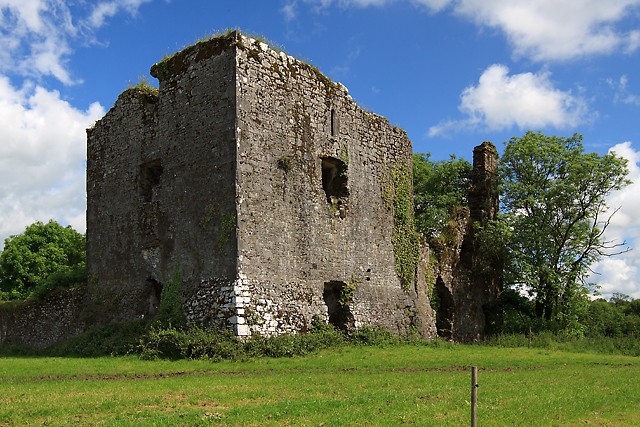
Overlooking Dungourney river to N; remains of rectangular tower (14m N-S; 11m E-W) now standing to 4 storeys but originally higher, and fragmentary remains of 17th-century range on N side, heavily overgrown. Tower entered at ground floor levels by door with pointed arch, in N wall. Ground floor chamber lit by central window opes in E, S and W walls. Directly above ground floor door similar door at 1st floor level. This gives access through lobby to door into main 1st floor chamber, and also to base of spiral stairs rising in NW corner, giving access to upper floors. At base of this stairs, door with pointed arch leads S into straight stairs descending towards ground floor window in W wall, lower part of stairs gone. First floor lit by central window ope in S wall; chamber covered by rounded wicker-centred vault (N-S axis). Second floor entered by door in NE corner from stairwell; lit by central windows in E, S and W walls; window in W wall has flat-headed light, chamfered on outside edge. Also at this level, and entered from stairwell, garderobe chamber in N wall, covered by segmental vault; murder-hole in floor covers 1st floor doorway. Inserted fireplace in SW corner. Very little of 3rd floor walls remain but E and W walls incline inwards indicating former covering vault (axis N-S). Only part of E wall and NW corner now stand of annex range abutting tower on N side; ivy-clad. Main features visible are fireplaces on E wall feeding tall rectangular chimney stack; also a number of gun loops. Structure has early 17th-century appearance. In farmyard to S inscribed arch stone (CO076-081----) from door is preserved, with inscription 'I.E.G. 1579'; these are initials of John Fitz-Edmond Fitzgerald, who may have renovated existing house at that date (Coleman 1915, 165-7); high enclosing walls on W side are more likely of 18th/19th-century date and associated with Cahermone House which stood short distance to SE (now demolished) .
Overlooking Dungourney river to N; remains of rectangular tower (14m N-S; 11m E-W) now standing to 4 storeys but originally higher, and fragmentary remains of 17th-century range on N side, heavily overgrown. Tower entered at ground floor levels by door with pointed arch, in N wall. Ground floor chamber lit by central window opes in E, S and W walls. Directly above ground floor door similar door at 1st floor…
From the National Monuments Service (Archaeological Survey of Ireland) record CO076-027001
The monument record does not grant public access. Check the route and ask the landowner before entering private land.
- What survives
- Recorded monument
Places near here
Photo credits
- Mike Searle, Wikimedia Commons · CC BY-SA 2.0
- National Inventory of Architectural Heritage
- Jim Woodward-Nutt, Wikimedia Commons · CC BY-SA 2.0
- Antiqueight, Wikimedia Commons · CC BY-SA 4.0
- David Dixon, Geograph · CC BY-SA 2.0
- Andy Beecroft, Geograph · CC BY-SA 2.0
- Mac McCarron, Geograph · Creative Commons Attribution-ShareAlike 2.0
- Sitomon, Wikimedia Commons · CC BY-SA 2.0
- Jean-Pol GRANDMONT, Wikimedia Commons · CC BY 2.5
- DeFacto, Wikimedia Commons · CC BY-SA 4.0
_-_geograph.org.uk_-_3036813.jpg/250px-Castles_of_Munster,_Cahermone,_Cork_(2)_-_geograph.org.uk_-_3036813.jpg "Photo: Mike Searle, Wikimedia Commons · CC BY-SA 2.0") Cahermone CastleCastle · 4 yd
Cahermone CastleCastle · 4 yd Westpark HouseHouse · 479 yd
 Broomfield HouseHouse · 1132 yd
 Jameson Distillery MidletonHeritage attraction · 1562 yd
 Midleton ira MonumentMemorial · 1.1 mi
 Nellie Cashman MonumentMemorial · 1.1 mi
 Ballintotis CastleCastle · 2.3 mi
 N25 Picnic SitePicnic place · 2.7 mi
 Grave YardGraveyard · 3.8 mi
 European Yew4.2 mi
 Princesstree4.2 mi
 Round Tower4.3 mi
More castles and forts in County Cork · All of County Cork
What do you know about this place?