What is recorded here
From OpenStreetMap (© OpenStreetMap contributors) n8914523242
Places near here
Photo credits
- Maker not stated on source page, it.pinterest.com
- Colin Park, Geograph · CC BY-SA 2.0
- Maker not stated on source page, www.istockphoto.com
- National Inventory of Architectural Heritage
- Maker not stated on source page, www.youtube.com
- Maker not stated on source page, animalia-life.club
- Maker not stated on source page, www.go-to-ireland.com
- Maker not stated on source page, www.alamy.com
- Maker not stated on source page, ie.pinterest.com
 Fairy fort / earthen ringfort in Kippagh (muskerry West By.)Fairy fort / earthen ringfort · 1.0 mi
Explorer Tom This fort overlooks the river from a slope, looking a bit scruffy with briars. It's got a proper entrance facing north…
 CurracahillMountain / peak · 1.1 mi
Explorer Tom Currahill would teach history by making everyone climb up while reciting dates, then erasing them if they got one…
 CaherbarnaghMountain / peak · 1.2 mi
Explorer Tom Caherbarnagh would buy a jetpack with a lotto win so it could travel to other mountains and gossip about the views. The…
 Caherbarnagh nw TopMountain / peak · 1.4 mi
Explorer Tom Caherbarnagh nw Top would review its visitors as 'adequate, though one lost a shoe'. It sits quietly in the northwest…
 Church in Nohaval DalyChurch · 4.2 mi
Explorer Tom Church in Nohaval Daly is just grass-covered mounds that locals call 'The Little Church', which sounds like a pet name…
 Nohoval BridgeBridge · 4.8 mi
Explorer Tom Nohoval Bridge is solid rubble with cut-stone voussoirs that probably cost a fortune back in the day. It’s a testament…
 Fairy fort / earthen ringfort in Ahane UpperFairy fort / earthen ringfort · 4.8 mi
Explorer Tom Fairy fort / earthen ringfort in Ahane Upper has a massive view from the ridge top. There are old lime kilns inside, so…
 Church (Site of)Church · 4.9 mi
Explorer Tom Church in Nohaval Lower is hidden in a graveyard. The 1842 map showed ruins, but now there’s no trace at all. Just dirt…
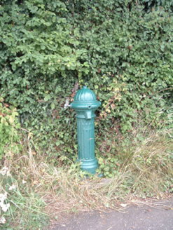 water pump5.9 mi
Explorer Tom Water pump in Mullaghroe North has been standing there since the 1880s, looking very Victorian about it. It’s a…
 DolmenAnomalous stone group · 5.9 mi
Explorer Tom Dolmen in Two Gneeves is two stones stacked on top of each other in a fence. It might be natural, but let's pretend…
 Standing stone in Two GneevesStanding stone · 6.2 mi
Explorer Tom Standing stone in Two Gneeves, County Cork was recorded by Bowman but nobody knows exactly where it is now. It had a…
 Standing stone in Knockduff Upper (duhallow By., Cullen Par.)Standing stone · 6.5 mi
Explorer Tom Standing stone in Knockduff Upper was recorded by Broker as three feet high and about a ton weight. It broke in 1934…
More mountains and hills in County Cork · All of County Cork

What do you know about this place?Tap to add a comment or ask a question