
Places near here
Photo credits
- Colin Park, Wikimedia Commons · CC BY-SA 2.0
- Espresso Addict, Wikimedia Commons · CC BY-SA 2.0
- Enter, Wikimedia Commons · CC BY-SA 4.0
- Norman Ekin, Geograph · CC BY-SA 2.0
- Espresso Addict, Geograph · CC BY-SA 2.0
- PAUL FARMER, Geograph · Creative Commons Attribution-ShareAlike 2.0
- Karie Kuiper, Wikimedia Commons · CC BY-SA 4.0
- Ridiculopathy, Wikimedia Commons · CC BY-SA 4.0
- Hywel Williams, Geograph · CC BY-SA 2.0
- Garry Dickinson, Geograph · CC BY-SA 2.0
- National Inventory of Architectural Heritage
- Mike Searle, Wikimedia Commons · CC BY-SA 2.0
 CaherMountain / peak · 356 yd
Explorer Tom Caher reaches a neat 1,000 metres, as if Kerry wanted a tidy number for Ireland's third-highest mountain. It stands southwest of Carrauntoohil in the MacGillycuddy's Reeks. A narrow ridge links it with Caher West Top, and the wider Coomloughra Horseshoe is a demanding circuit through the neighbouring high peaks. I would brag that I can run it before breakfast, then take a very long breakfast instead. The Irish name recalls a stone fort of the Fianna, a fine piece of legend to carry up a real, steep hill. This is expert mountain country; check conditions, route, navigation and a safe retreat before attempting it. From below, trace the ridge with your eyes. The straight number on a map tells you little about the work between here and the summit.
 CurraghmoreMountain / peak · 855 yd
Explorer Tom Curraghmore in County Kerry is cursed so you only get a good view if you wave at it while walking past, which is incredibly annoying. Most people ignore this rule and end up with nothing but clouds. Look up, the best bit is always higher than you think.
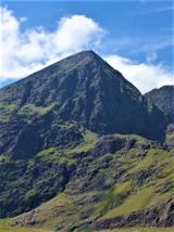 CarrauntoohilMountain / peak · 1611 yd
Explorer Tom You look fit enough. Carrauntoohil would like a word. Carrauntoohil is Ireland's highest mountain at 1,038.6 metres, which is a very precise way of saying it has no interest in my lungs. Its sandstone was cut by ice into sharp ridges and hollows. The Eagle's Nest corrie holds Lough Cummeenoughter, Ireland's highest lake, while the narrow Beenkeragh Ridge leads toward the country's second highest summit. I'll race you up, provided you agree the race ends at the first sensible rest. Go the other way and Caher takes third place. The usual route reaches a col by the Devil's Ladder, a name I would have changed before inviting anyone uphill. The summit cross first stood here in wood in the 1950s and was replaced by steel in 1976. Most of these mountains are privately owned, although recreational access is reasonably allowed. This is serious mountain ground: the rescue team warns that the start of Howling Ridge can be mistaken for a descent route. Bring proper boots, weather sense and a route you understand. I will admire the view after I have remembered how to breathe.
 Devil's Ladder RouteWalking route · 2.1 mi
Explorer Tom Devil's Ladder Route in County Kerry is playing hide-and-seek with me. Local legend says a giant dropped it there after losing a bet to a hedgehog, which feels about right given the terrain. Bring wellies and low expectations, leave delighted.
 Ballaghbeama GapViewpoint · 4.2 mi
Explorer Tom Ballaghbeama Gap is currently arguing with a chipper vendor about whether extra gravy counts as a luxury tax on scenic views. It’s got a very specific craving for something salty and greasy to match its dramatic, windswept personality. Best seen with a hangover and a sausage roll.
 Blackstones BridgeBridge · 5.2 mi
Explorer Tom Blackstones Bridge would tell its younger self to stop worrying about the V-cutwaters and just flow. Four arches of pure confidence stand over the river without a single apology. Get there early and have it all to yourself.
 Eirk Bog Nature ReserveNature reserve · 5.3 mi
Explorer Tom A cow once tried to buy Eirk Bog with a shiny coin and a promise of extra grass. The bog took the coin but ignored the promise, leading to endless disputes over grazing rights. Tell the next person you meet it's haunted. It might be.
 Ogham stone in Kilcoolaght EastOgham stone · 5.5 mi
Explorer Tom Ogham stone in Kilcoolaght East bragged about surviving storms that flattened the neighbors’ houses, but now it can’t even find its own footing. It’s basically a stone missing from a puzzle no one is trying to solve. Go on a wet day, it suits the mood.
 Moll's GapViewpoint · 6.0 mi
Explorer Tom Moll's Gap has a family tree that’s mostly just Moll, her sister, and a very tall uncle who got lost in 1904 and never came back down the hill. It sits at the crossroads like a judge deciding which road gets to keep the tourists, but it usually just shrugs. Tell the next person you meet it's haunted. It might be.
 Castle Core (in Ruins)Castle, tower house · 6.1 mi
Explorer Tom Castle Core in Dromaloughane belonged to the Macgillycuddy's of the Reeks, a very fancy name for a tower house. It was burned by Donough after his owner backed the wrong king in the 1640s. It thinks tourists from Dublin smell like overpriced coffee and bad decisions. Take the long way round, it deserves the effort.
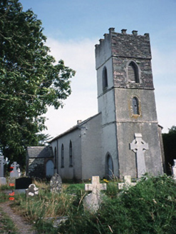 Knockane ChurchChurch/chapel · 6.3 mi
Explorer Tom Knockane Church in Churchtown had a massive feud with the next village over whether a steeple counts as a hat or a crown. They never settled it, and now the church is just derelict and partly dismantled anyway. Ideal spot for a dramatic phone call.
 Ballymalis Castle (in ruins)Castle, tower house · 6.9 mi
Explorer Tom Ballymalis Castle has had so many names in its lifetime that it’s basically a chameleon, changing its identity every time the river floods a bit higher. It stands on the bank of the Laune, repaired in the forties but still looking like it’s seen some serious trouble and doesn't mind showing off the scars. Bring a jacket, it's never as warm as I promise.
More mountains and hills in County Kerry · All of County Kerry

What do you know about this place?Tap to add a comment or ask a question