
What is recorded here
From the National Monuments Service (Archaeological Survey of Ireland) record CO070-122
Places near here
Photo credits
- Jonathan Thacker, Geograph · Creative Commons Attribution-ShareAlike 2.0
- Maker not stated on source page, www.gettyimages.com
- Ceoil ( talk ) ( Uploads ), Wikimedia Commons · Public domain
- National Inventory of Architectural Heritage
- Maker not stated on source page, it.pinterest.com
- Kmcnamee, Wikimedia Commons · CC BY-SA 4.0
- Maker not stated on source page, en.wikipedia.org
 Carrigaphooca BridgeBridge · 715 yd
Explorer Tom Carrigaphooca Bridge has six arches and looks like it’s been rendered to hide its age since 1820. It used to be on the…
 Stone CircleStone circle, multiple-stone · 911 yd
Explorer Tom Stone Circle in Carrigaphooca has been hiding a scandal for centuries: the púca who lived there was actually just a…
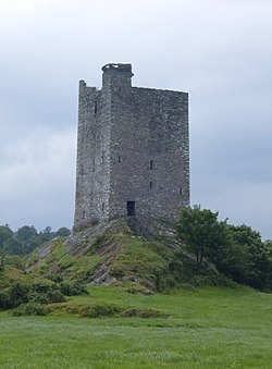 Carrigaphooca CastleCastle · 1040 yd
Explorer Tom Carrigaphooca Castle has a púca in its name and a rock under its feet, enough for me to spin a tale before we even…
Carrigaphooca Castle (in ruins)Castle, tower house · 1040 ydExplorer Tom Carrigaphooca Castle sits on a rocky outcrop like a king on a throne. The MacCarthys built it back in 1436, which is…
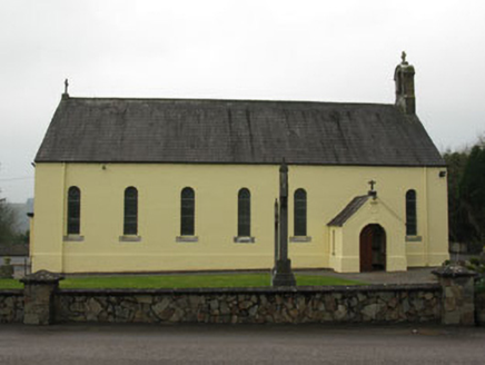 St Abina's Roman Catholic ChurchChurch/chapel · 1532 yd
Explorer Tom St Abina's Roman Catholic Church in Garranenagappul is rocking with its barn-style charm from 1877. It replaced an…
 Fairy fort / earthen ringfort in GarranenagappulFairy fort / earthen ringfort · 1540 yd
Explorer Tom Fairy fort in Garranenagappul has a limekiln built right into its bank, which is weird but cool. The stone facing looks…
 Clondrohid GAA pitchGAA ground · 1632 yd
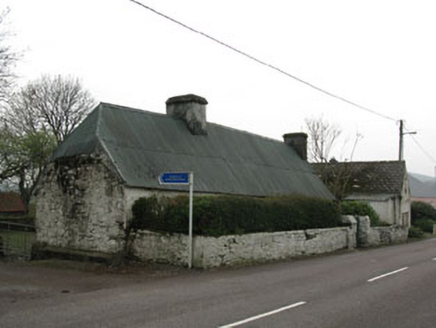 farm house1695 yd
Explorer Tom Farm house in Garranenagappul is built from local fieldstone, meaning every rock has been kicked by a farmer for…
 hall1745 yd
Explorer Tom Hall in Garranenagappul is hiding a legend about a giant who used to use its round-headed door as a hat stand, which is…
 Bullaun stone in Glebe (muskerry West By., Clondrohid Par.)Bullaun stone · 1.1 mi
Explorer Tom Bullaun stone in Glebe is cemented into place outside a graveyard, which is either very practical or incredibly rude.…
 Garranenagappul BridgeBridge · 1.1 mi
Explorer Tom Garranenagappul Bridge spans the Foherish, covering its rubble core with rendered paint because it’s shy about its own…
 sign post1.1 mi
Explorer Tom Sign post in Caherkeegane is complaining to the council that its harp motif is out of fashion. It’s been standing there…
More archaeology and monuments in County Cork · All of County Cork

What do you know about this place?Tap to add a comment or ask a question