
Places near here
Photo credits
- A.-K. D., Wikimedia Commons · CC BY-SA 4.0
- Maker named on the Wikimedia Commons picture page · CC BY-SA 3.0
- kevin higgins, Wikimedia Commons · CC BY-SA 2.0
- kevin higgins, Geograph · CC BY-SA 2.0
- A.-K. D., Wikimedia Commons · CC0
- Rüdiger Wölk This photo was taken by Rüdiger Wölk . Please credit this photo Rüdiger Wölk, Münster . View all photos (large page) of Rüdiger Wölk I would also appreciate an email to rudiger.wolk@gmail.com with details of use. Für Hinweise auf Veröffentlichungen (rudiger.wolk@gmail.com) oder Belegexemplare bin ich Ihnen dankbar., Wikimedia Commons · CC BY-SA 2.5
 Church in KillareeChurch · 447 yd
Explorer Tom Church in Killaree is sitting on top of a big old ringfort, which looks like it wrote its dating profile as 'single, loves stone circles, no drama.' It’s been waiting for someone to notice it since before we had proper roads, let alone smartphones. Walk past slowly like you're in a film.
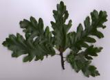 Turkey Oak1416 yd
Explorer Tom Turkey Oak in County Kilkenny holds a fake world record for being the most confused tree in Ireland, having been misidentified as something else for the last century. It’s not even angry about it, just thoroughly unimpressed by the whole thing. Hang around long enough and you'll hear a story from a local.
 Saint Nicholas's Catholic ChurchChurch/chapel · 1556 yd
Explorer Tom Saint Nicholas's Catholic Church in Leugh, County Kilkenny has strict rules: no smiling too hard at its dour limestone face because it’s trying to look stern. It carved itself with such intensity that even the sheep respect the quiet dignity of the whole operation. Tell it you’re just passing through, not here to be judged by the stonework.
 Graveyard in ThreecastlesGraveyard · 1.0 mi
Explorer Tom Graveyard in Threecastles would spend its lotto win on a new fence because the current one is letting the cows in and they are very rude about the whole thing. It’s a nightmare for them. Have a chat with it, nobody's watching.
 Castle (in ruins)Castle, tower house · 1.0 mi
Explorer Tom Castle in Threecastles would bring a bottle of wine and zero conversation to any party. It sits on the ridge like a stoic uncle. Tell it a joke, it's been a long time since anyone did.
 Bawn in BoolysheaBawn · 2.6 mi
Explorer Tom Bawn in Boolyshea is surrounded by gorse that has strong opinions about your clothing choices and will absolutely punish you if you wear blue tights. The local who claims he invented the bawn is currently hiding in a bush, so don’t ask him questions or he might get angry. Snap one photo, then put the phone away and actually look.
 ToberlaghteenHoly well · 3.6 mi
Explorer Tom Toberlaghteen near Moat has an ash tree that outlived everyone who worshipped there. A poet fell in the ditch nearby, probably after too much poetry. The water still bubbles with unearned confidence. Pretend you're a lost aristocrat, nobody will check.
 Font in Freshford LotsFont · 3.8 mi
Explorer Tom Font in Freshford Lots swears it knows where the real treasure is buried after a few pints with the locals. It’s just sitting left of the altar, judging your baptismal choices from across the room. If anyone asks, Tom sent you.
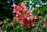 Red horse-chestnut3.9 mi
Explorer Tom Red horse-chestnut in County Kilkenny has already decided what will go on its tombstone: 'Loved by no one, admired by a few, and very red.' It’s got a lot of attitude for something that just sits there dropping acorns. Stand back, squint, and it looks like a castle.
 Emma Jane Browne-ClaytonMemorial · 3.9 mi
Explorer Tom Emma Jane Browne-Clayton is tucked away in a community hall in Freshford, County Kilkenny, where she’s probably pretending to be a very serious piece of furniture. Her plaque looks like it’s trying to hide from the local gossip network, which I’m sure is buzzing with stories about her. Find a local and ask them the real story, then come back and tell me.
 St. Mogarra’s WellSpring · 7.5 mi
Explorer Tom St. Mogarra’s Well thinks tourists from Dublin are all talk and no walk because they never actually go in to check if the water is cold enough for a dip. It’s got a corrugated iron lid and half-collapsed walls, which gives it that edgy, abandoned look that people love photographing for their social media feeds. Make up your own legend and I'll swear it's true.
 Tullaherin Round TowerVisitor attraction · 12 mi
Explorer Tom Tullaherin Round Tower has strict rules for visitors: don't touch anything, don't breathe too loud, and definitely don't ask it how old it is because it will get defensive. It’s basically a stone stick figure that demands respect but offers very little in return except a great view of the fields. Hum something sad nearby, it adds atmosphere.
More archaeology and monuments in County Kilkenny · All of County Kilkenny

What do you know about this place?Tap to add a comment or ask a question