
What is recorded here
On a prominent E-W ridge running along the S bank of the River Nore. The slight elevation gives a commanding view across the Nore valley in all directions and over the fording point of the river. The residential tower is attached to the W end of a medieval church (KK014-025003-), orientated E-W, which is situated in the N portion of a roughly rectangular graveyard (KK014-0225007-). The W end of the church was rebuilt and is contemporary with the tower which is the same width as the church. A four-storey tower (int. dims. 6m N-S; 5m E-W; S wall T 1.4m) which was entered at the E end of the W wall. The tower and church are not interconnected at ground level. The doorway is protected by a murder-hole over head. There is a vault over the ground-floor chamber, the upper levels are carried on timber floors which rested on corbels. A mural stair rises in the W wall to a spiral stair in the NW angle which gives access to the chambers for the first floor upwards. The steps have been deliberately removed in relatively recent times to prevent access to the upper levels. There is a mural passage in the N wall at first-floor level which gives access to a stair at the E end leading to the wall-walk of the church. There is the exit of a garderobe chute at the N end of the W wall. The upper levels have large windows and fireplaces. When it was visited by the Ordnance Survey in 1839 it was, 'so covered with ivy that the door and windows were quite invisible, but there is a forced doorway in western side' (O'Flanagan ed. 1930, vol. 1 (201). The tower is described by Carrigan (1905, vol. 2, 267-8) Carrigan (ibid.) as, 'the presbytery, a strong castle 35 ft. [c. 10.6m] long, with walls 8 [c. 2.4m] or 9 ft. [c. 2.7m] thick...it is at present about 24 ft. [c. 7.3m] high'. Gibb (1948, 26) mentions that the tower, 'is now used as a barn'.
On a prominent E-W ridge running along the S bank of the River Nore. The slight elevation gives a commanding view across the Nore valley in all directions and over the fording point of the river. The residential tower is attached to the W end of a medieval church (KK014-025003-), orientated E-W, which is situated in the N portion of a roughly rectangular graveyard (KK014-0225007-). The W end of the church was…
From the National Monuments Service (Archaeological Survey of Ireland) record KK014-025004
The monument record does not grant public access. Check the route and ask the landowner before entering private land.
- What survives
- Recorded monument
Places near here
Photo credits
- A.-K. D., Wikimedia Commons · CC BY-SA 4.0
- National Inventory of Architectural Heritage
- Maker named on the Wikimedia Commons picture page · CC BY-SA 3.0
- A.-K. D., Wikimedia Commons · CC0
- kevin higgins, Wikimedia Commons · CC BY-SA 2.0
- Rüdiger Wölk This photo was taken by Rüdiger Wölk . Please credit this photo Rüdiger Wölk, Münster . View all photos (large page) of Rüdiger Wölk I would also appreciate an email to rudiger.wolk@gmail.com with details of use. Für Hinweise auf Veröffentlichungen (rudiger.wolk@gmail.com) oder Belegexemplare bin ich Ihnen dankbar., Wikimedia Commons · CC BY-SA 2.5
.jpg/250px-Bealtaine_offerings_at_Threecastles_Church_(62021).jpg "Photo: A.-K. D., Wikimedia Commons · CC BY-SA 4.0") Church (in ruins)Church · 10 yd
Church (in ruins)Church · 10 yd Graveyard in ThreecastlesGraveyard · 15 yd
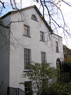 The Old RectoryRectory/glebe/vicarage/curate's house · 59 yd
 Turkey Oak510 yd
 CastleCastle, unclassified · 1.9 mi
 Saint Coleman's WellSpring · 2.2 mi
 Castle (in Ruins)Castle, tower house · 2.3 mi
.jpg/250px-Junction_and_Buildings_-_geograph.org.uk_-_6511084_(cropped).jpg "Photo: kevin higgins, Wikimedia Commons · CC BY-SA 2.0") RathbeaghFairy fort / earthen ringfort · 2.9 mi
RathbeaghFairy fort / earthen ringfort · 2.9 mi St. Catherines WellHoly well · 3.0 mi
 Red horse-chestnut3.4 mi
 Emma Jane Browne-ClaytonMemorial · 3.4 mi
 Donaghmore WellSpring · 4.8 mi
More castles and forts in County Kilkenny · All of County Kilkenny
What do you know about this place?