
What is recorded here
On E side of Cullen village; St Laserian's well (14026) located outside NE angle. Rectangular graveyard (c. 65m N-S; c. 30m E-W) enclosed by stone wall; 1842 OS 6-inch map shows N boundary c. 35m to S of present line. According to Grove White (1905-25, vol. 3, 89), walls repaired with stones from 'Cullen Monastery'…
Read the whole record
From the National Monuments Service (Archaeological Survey of Ireland) record CO029-076002
Places near here
Photo credits
- Maker not stated on source page, www.pinterest.com
- Maker not stated on source page, commons.wikimedia.org
- National Inventory of Architectural Heritage
- Maker not stated on source page, www.flickr.com
- Maker not stated on source page, www.youtube.com
- Maker not stated on source page, www.go-to-ireland.com
- Maker not stated on source page, ie.pinterest.com
- Maker not stated on source page, www.alamy.com
 Old Cullen CemeteryGraveyard · 18 yd
Explorer Tom Old Cullen Cemetery claims to be older than the village itself, which is a lie because the village didn't exist then.…
 Cullen GAA pitchGAA ground · 304 yd
 Cullen BridgeBridge · 489 yd
Explorer Tom Cullen Bridge is pretending to be an old stone bridge when it’s actually a twentieth-century imposter in a trench coat.…
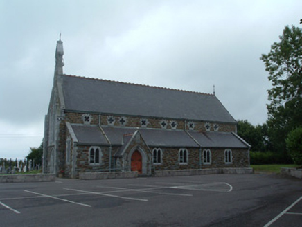 Church of the Immaculate ConceptionChurch/chapel · 565 yd
Explorer Tom Church of the Immaculate Conception in Mullaghroe South uses polychromy to look impressive, but it's really just trying…
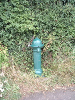 water pump791 yd
Explorer Tom Water pump in Mullaghroe North has been standing there since the 1880s, looking very Victorian about it. It’s a…
 Fulacht fia in Church HillFulacht fia · 1153 yd
Explorer Tom Fulacht fia in Church Hill was levelled back in '67. Now it’s just a grassy spread by a stream. The mound is gone, but…
 Fairy fort / earthen ringfort in Ahane UpperFairy fort / earthen ringfort · 1380 yd
Explorer Tom Fairy fort / earthen ringfort in Ahane Upper is doing its best impression of a ghost since the quarry swallowed it…
 DolmenAnomalous stone group · 1584 yd
Explorer Tom Dolmen in Two Gneeves is two stones stacked on top of each other in a fence. It might be natural, but let's pretend…
 Standing stone in Ahane UpperStanding stone · 1691 yd
Explorer Tom Standing stone in Ahane Upper in County Cork is standing there looking like it hasn't slept since the 1800s. It’s just…
 Burial ground in Church HillBurial ground · 1696 yd
Explorer Tom Burial ground in Church Hill would post 'Feeling sunken' on social media, followed by seventeen photos of its own scarp…
 Standing stone in Knockduff Upper (duhallow By., Cullen Par.)Standing stone · 1729 yd
Explorer Tom Standing stone in Knockduff Upper was recorded by Broker as three feet high and about a ton weight. It broke in 1934…
 Standing stone in Two GneevesStanding stone · 1.1 mi
Explorer Tom Standing stone in Two Gneeves, County Cork was recorded by Bowman but nobody knows exactly where it is now. It had a…
More archaeology and monuments in County Cork · All of County Cork

What do you know about this place?Tap to add a comment or ask a question