
What is recorded here
From the National Monuments Service (Archaeological Survey of Ireland) record CL056-010001
Places near here
Photo credits
- National Inventory of Architectural Heritage
- Charles W Glynn, Geograph · CC BY-SA 2.0
- Matteo.mazza.91, Wikimedia Commons · CC BY-SA 4.0
- John Morton from Adelaide, Wikimedia Commons · CC BY 2.0
- Dmitrij Rodionov, Wikimedia Commons · CC BY-SA 4.0
- Colin Park, Geograph · CC BY-SA 2.0
- Simon Huguet, Geograph · CC BY-SA 2.0
- Garry Dickinson, Wikimedia Commons · CC BY-SA 2.0
- John Shorten, Geograph · CC BY-SA 2.0
- Charles W Glynn, Wikimedia Commons · CC BY-SA 2.0
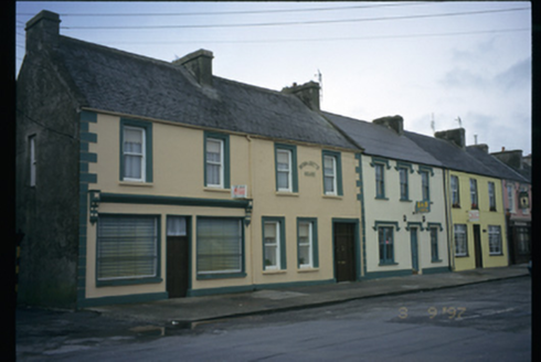 Bernadette HouseHouse · 1.5 mi
Explorer Tom Bernadette House in Dough gave up meat for Lent but kept the shopfront until 1920, which feels like cheating. The name sounds like a saint, but the building looks like it’s just hiding from the rain. Stand where the owner stood and practise looking smug.
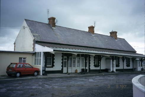 Kilkee Railway StationRailway station · 1.6 mi
Explorer Tom Kilkee Railway Station in Dough is now a house, which means the trains are just jealous it got domesticated. A tale from 1892 says it was built for speed, but now it's stuck in traffic with your nan. Bring your nan, she'll know more than me.
 George's HeadHeadland · 2.1 mi
Explorer Tom George's Head sits by Moore Bay in Kilkee, a spot where history and sea meet on this stretch of coast.
 Kilkee CliffsViewpoint · 2.8 mi
Explorer Tom Kilkee Cliffs has me imagining cliffs that are more about the view than the actual rock formations
 IllaunawhillaIslet · 3.1 mi
Explorer Tom Illaunbeg, you're a quiet islet. I wonder if there's anything special about your rocky terrain.
 Bishop's IslandIslet · 3.5 mi
Explorer Tom Bishop's Island, an islet in County Clare, is known for its rugged cliffs and hidden coves.
 Foohagh PointHeadland · 3.7 mi
Explorer Tom Foohagh Point juts out proudly, where rough seas near Illaunadoon crash against the headland in County Clare.
 Doonbeg Castle (in Ruins)Castle, tower house · 4.8 mi
Explorer Tom Doonbeg Castle is sitting by the bridge looking like it gave up halfway through being impressive. Its dating profile says 'moody' and 'slightly damp.' Snap one photo, then put the phone away and actually look.
 Doonmore CastleRuins · 4.8 mi
Explorer Tom Doonmore Castle is recorded as ruins in County Clare, part of the Castles of Munster: Doonmore, Clare.
 Dunlicky PointViewpoint · 5.1 mi
Explorer Tom Dunlicky Point has me wondering if the inlet is just a fancy name for a puddle in the sky
 St. Senan's WellSpring · 5.8 mi
Explorer Tom St. Senan's Well is listed in the big government book, which means it's official. SMR number and all that boring stuff. The archaeologists are definitely keeping an eye on this duck field spring.
 CLogaus or Round TowerRound tower · 6.4 mi
Explorer Tom CLogaus or Round Tower on Scattery Island is twenty-six metres high but has no floors or ladders left inside. Tell the next person you meet it's haunted. It might actually be true.
More archaeology and monuments in County Clare · All of County Clare

What do you know about this place?Tap to add a comment or ask a question