
What is recorded here
From the National Monuments Service (Archaeological Survey of Ireland) record DG004-051
Places near here
Photo credits
- National Inventory of Architectural Heritage
- MarieDub, Wikimedia Commons · CC BY-SA 4.0
- N Chadwick, Geograph · CC BY-SA 2.0
- Andreas F. Borchert, Wikimedia Commons · CC BY-SA 4.0
- Donegal Daily; photographer not named, Source publisher
- Maker not stated on source page, br.pinterest.com
- Maker not stated on source page, www.pinterest.com
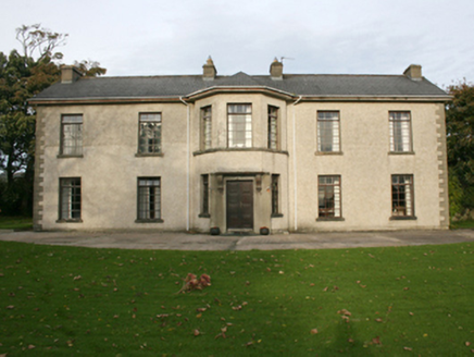 Rockville HouseHouse · 1045 yd
Explorer Tom Rockville House has been standing in Drumcarbit since around 1800, serving as a Presbyterian manse for families like…
 Malin BridgeBridge · 1072 yd
Explorer Tom Malin Bridge has been arching over the Ballyboe River since about 1760, its ten rubble stone spans creating a truly…

 E. McCleanRestaurant · 1132 yd
Explorer Tom E. McClean is a great restaurant now, with lunch or dinner worth turning up for. Tom says that if you're lucky, you…
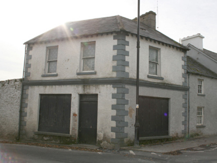 public house1155 yd
Explorer Tom This public house in Carrowmore sits quietly on the village green corner, built c. 1820. Local legend has it that…
 water pump1255 yd
Explorer Tom Water pump in Carrowmore has been standing since about 1900, its rams head grip and cow-tail handle looking like a…
 telephone box1263 yd
Explorer Tom Telephone box in Carrowmore is a c. 1950 moulded concrete relic that has outlived its usefulness but not its charm. It…
 Clonca Church of Ireland ChurchChurch/chapel · 1293 yd
Explorer Tom Clonca Church of Ireland Church in Malin is a proper 1827 survivor with that classic Gothic vibe. It was partly funded…
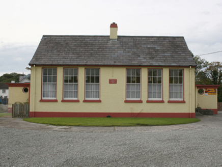 Scoil Treasa Naofa MalainnSchool · 1305 yd
Explorer Tom Scoil Treasa Naofa Malainn is a neat little time capsule from 1951. It’s a standard Office of Public Works design, but…
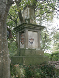 monument1367 yd
Explorer Tom This monument in Carrowmore has been rotting away since c. 1860, its marble plaques now illegible. But those lily-leaf…
 Connolly Park, MalinGAA ground · 1413 yd
Explorer Tom Connolly Park is Malin’s proud patch of Gaelic games, up near the tip of Inishowen where an away team has already had…
 Standing stone in Churchland QuartersStanding stone · 1538 yd
Explorer Tom Standing stone in Churchland Quarters is playing hide-and-seek with me. The first edition map noted a 'Stone' here, but…
 Balleeghan Upper CairnCairn, unclassified · 1674 yd
Explorer Tom Balleeghan Upper Cairn is a 6.8-metre-wide stone mound with a kerb of larger stones. At 1.8 metres high, it occupied…
More archaeology and monuments in County Donegal · All of County Donegal

What do you know about this place?Tap to add a comment or ask a question