What is recorded here
From OpenStreetMap (© OpenStreetMap contributors) n3814740961
Places near here
Photo credits
- National Inventory of Architectural Heritage
- Didier Descouens, Wikimedia Commons · CC BY-SA 4.0
- Kenneth Allen, Geograph · CC BY-SA 2.0
- Dean Molyneaux, Geograph · CC BY-SA 2.0
- David Dixon, Geograph · CC BY-SA 2.0
- Jonathan Wilkins, Wikimedia Commons · CC BY-SA 2.0
- louise price, Wikimedia Commons · CC BY-SA 2.0
- N Chadwick, Geograph · CC BY-SA 2.0
- Kenneth Allen, Wikimedia Commons · CC BY-SA 2.0
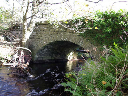 Moneymore BridgeBridge · 490 yd
Explorer Tom Moneymore Bridge has one dressed stone arch over the Ballintra River, dating from around 1800. The old survey notes former corn mills close by, though their link to this bridge is uncertain. I like the idea of the bridge keeping watch while the mill story waits for more clues.
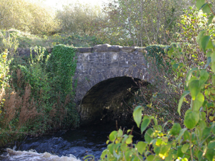 Connor's BridgeBridge · 676 yd
Explorer Tom Connor's Bridge carries a road over the Ballintra River at a junction of three roads. Built around 1820, its single stone arch has to choose one river but the roads get three directions. The bridge might demand a signpost to settle the argument.
 Hawthorn2.4 mi
Explorer Tom A lovely Hawthorn tree in Donegal, possibly needing permission to enjoy its blossoms and natural grace.
 MurvaghOfficial bathing water · 2.6 mi
Explorer Tom Murvagh Beach has a wartime lookout hut that Joy Browne, writing for Donegal tourism, remembers playing in as a child. She says erosion has since sunk it into the sand and made entry impossible. A lookout hut retiring by burying its feet is theatrical enough for me; I would leave it to its rest.
 RossnowlaghOfficial bathing water · 3.5 mi
Explorer Tom Rossnowlagh seems determined to be a whole journey rather than one beach. Donegal tourism runs it from Coolmore’s cliffs to Carrickfad’s rock. I would need a bigger postcard for that stretch of golden sand; the surfers have probably had that problem for years.
 Rooney's IslandIslet · 3.6 mi
Explorer Tom Rooney's Island was once home to the O'Maoldory Clan, who ruled as Kings of Tir Conaill. I imagine a very serious coronation ceremony taking place on a patch of ground that barely fits a picnic blanket.
 Sheebarran RingfortFairy fort / earthen ringfort · 3.8 mi
Explorer Tom Sheebarran Ringfort is a massive circular space with a huge bank and a deep fosse. It’s perched on a ridge, making it look like the most important hill in the entire county.
 Ballyboyle IslandIslet · 4.5 mi
Explorer Tom Ballyboyle Island takes its name from the O’Boyle clan, sub-chieftains of the O’Donnells who once ruled from Donegal Castle.
 Kilbarron Old Church GraveyardGraveyard · 4.7 mi
Explorer Tom Kilbarron Old Church Graveyard features a 15th or 16th century ruin with a 2.4m high E gable that has no window at all. That is quite the dramatic lighting choice for a place meant to let in some divine brightness.
 Salthill CabinCafé · 4.9 mi
Explorer Tom Salthill Cabin is likely just a shed with a coffee machine and delusions of grandeur. It’s in County Donegal, so expect rain to pour straight through the roof. Take a photo if you find any actual salt anywhere.
 Standing stone in Townparks (ballyshannon Ed)Standing stone · 5.2 mi
Explorer Tom Standing stone in Townparks has markings like 'cats paws' on the E side. Did a giant cat nap there? I swear I can still smell the tuna.
 Dark Cliffs at KilbarronPublicly named cliff or headland · 5.2 mi
Explorer Tom The Dark Cliffs at Kilbarron sound moody and magnificent, perfect for a quick look if you can find a safe spot.
More mountains and hills in County Donegal · All of County Donegal

What do you know about this place?Tap to add a comment or ask a question