What is recorded here
From the National Monuments Service (Archaeological Survey of Ireland) record SL012-104
Places near here
Photo credits
- Maker not stated on source page, www.pinterest.com
- Maker not stated on source page, irishheritagenews.ie
- Maker not stated on source page, en.wikipedia.org
- Maker not stated on source page, in.pinterest.com
- Maker not stated on source page, www.alamy.com
- National Inventory of Architectural Heritage
- Maker not stated on source page, commons.wikimedia.org
- Michael Dibb, Geograph · CC BY-SA 2.0
- Kmcnamee, Wikimedia Commons · CC BY-SA 4.0
- Willow, Wikimedia Commons · CC BY 2.5
 CastleCastle, unclassified · 1 yd
Explorer Tom Castle in Doonflin Lower has a family tree that’s mostly invented by drunk Italians in the 1590s. We know it exists…
 Fairy fort / earthen ringfort in Carrownacreevy (tireragh By., Aughris Ed)Fairy fort / earthen ringfort · 788 yd
Explorer Tom Fairy fort / earthen ringfort in Carrownacreevy: Someone wrote a bad poem about this place once, rhyming 'mud' with…
 Earthwork in Carrownacreevy (tireragh By., Aughris Ed)Earthwork · 806 yd
Explorer Tom Earthwork in Carrownacreevy is a gentle bump that might be an earthwork or might just be a hill that woke up feeling…
 Enclosure in Carrownacreevy (tireragh By., Aughris Ed)Enclosure · 839 yd
Explorer Tom Enclosure in Carrownacreevy: This oval hollow bragged about surviving a massive storm, even though it was just sitting…
 Fairy fort / earthen ringfort in BallyfarisFairy fort / earthen ringfort · 1150 yd
Explorer Tom Fairy fort / earthen ringfort in Ballyfaris has been levelled on one side, which makes it look like it’s leaning…
 Stone circle Giants GraveMegalithic structure · 1588 yd
Explorer Tom Giants Grave in Farranyharpy has strong opinions about modern buildings, mostly that they look flimsy. It’s a…
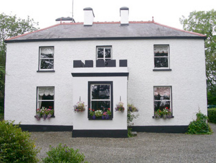 Fortlaurel HouseHouse · 1738 yd
Explorer Tom Fortlaurel House in Ardogelly is well-sited on a winding driveway, looking like it just stepped out of a country estate…
 Templeboy ChurchRuins · 1.6 mi
Explorer Tom Templeboy Church in County Sligo was built on a bargain where someone promised free ale for life in exchange for the…
 Aughris BeachBeach / strand · 1.9 mi
Explorer Tom Aughris Beach is the smaller sandy stop beside Aughris Head in County Sligo, near the thatched Beach Bar and path…
 St. Farnan's Park, TempleboyGAA ground · 2.2 mi
 Seamie Donegan Memorial Park, St. Patrick's GAA, Skreen/DromardGAA ground · 3.3 mi
 European ash4.7 mi
Explorer Tom European ash in County Sligo handles nosey neighbours by simply dropping a leaf directly on their heads every single…
More historic places in County Sligo · All of County Sligo

What do you know about this place?Tap to add a comment or ask a question