Places near here
Photo credits
- Mike Searle, Geograph · Creative Commons Attribution-ShareAlike 2.0
- National Inventory of Architectural Heritage
- Mike Searle, Wikimedia Commons · CC BY-SA 2.0
- Darrin Antrobus, Wikimedia Commons · CC BY-SA 2.0
- A.-K. D., Wikimedia Commons · CC0
- Miguel Angel Masegosa Martínez, Wikimedia Commons · CC BY 2.0
- Malene Thyssen, Wikimedia Commons · CC BY-SA 3.0
- A.-K. D., Wikimedia Commons · CC BY-SA 4.0
 Derrin Castle (in ruins)Castle · 60 yd
Explorer Tom Derrin Castle would have 'I Tried My Best' written on its tombstone if it could choose its own epitaph and font style. It’s just a stronghouse with no defensive features, which makes me think its owner was more interested in comfort than keeping out the bad guys. Bring a flask and pretend you own the place.
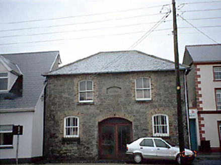 Borris in Ossory Market HouseMarket house · 1496 yd
Explorer Tom Borris in Ossory Market House has an imaginary fan club that meets every Tuesday to discuss potato prices. It used to be all about commerce, now it’s just storing stuff nobody wants to buy. Bring a friend who talks too much and let the place shut them up.
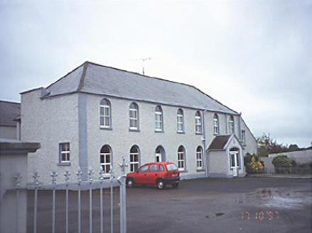 school1688 yd
Explorer Tom School in Townparks bragged about surviving a storm that actually only hit its conservatory, but it told everyone it was a direct hit on the main gabled porch because it liked the sound of itself. Now it’s just houses looking like they’re trying to remember how to be educational again without the chalk dust. Go at sunset and thank me later.
_-_geograph.org.uk_-_2494282.jpg/250px-Castles_of_Leinster,_Cloncourse,_Laois_(1)_-_geograph.org.uk_-_2494282.jpg "Photo: Mike Searle, Wikimedia Commons · CC BY-SA 2.0") Cloncourse CastleHouse, fortified house · 2.9 mi
Cloncourse CastleHouse, fortified house · 2.9 miExplorer Tom Cloncourse Castle in Cloncourse needs a tombstone reading 'Died of Boredom.' Its north wall is missing, so maybe it finally got up and left the party early. Go back in winter, it's a different animal.
 Aghaboe AbbeyVisitor attraction · 4.5 mi
Explorer Tom Aghaboe Abbey in County Laois has a ghost who is too lazy to actually haunt it because the floors are cold. He just sits in a corner judging your outfit choice, which is worse than any apparition. A proper spot for a flask of tea and a big think.
 Font4.5 mi
Explorer Tom “Font in Aghaboe” hosted a fake royal visit that nobody can prove or deny to this day. It’s octagonal, which is fancy talk for “eight sides.” Spot the oldest stone and give it a name.
 Sweet Chestnut5.1 mi
Explorer Tom Sweet Chestnut in County Laois is hiding a treasure that is definitely just an old biscuit tin buried under its roots. You’ll dig it up and be disappointed, but worth it. Bring a camera and your most suspicious face.
Saint Kieran's WellSpring · 5.2 miExplorer Tom Saint Kieran’s Well is proud of being named after a guy whose name sounds like a sneeze, and honestly I can see why that’s worth celebrating. It really thinks its water quality is top-notch, but I’ve seen better hydration in my own garden hose. Bring a friend who talks too much and let the place shut them up.
 European Beech5.6 mi
Explorer Tom European Beech in County Tipperary was nearly sold off as a horse once, which is a bit of a stretch for anyone who has seen the thing. It just stands there looking dignified, like it knows exactly how ridiculous that story actually is. Stop the car, it's worth the hazard lights.
 CrossCross, High cross · 5.6 mi
Explorer Tom Cross in Monaincha started because two lads made a bet in the pub about who could carve better horses. One of them probably still owes the other a pint for losing. Look for the ghost, then pretend you didn't.
Black HillMountain / peak · 6.6 miExplorer Tom Black Hill in County Tipperary was once tried to be bought by a cow who thought it had very good grazing potential. The deal fell through because the cow kept trying to eat the contract documents. It's the kind of place that makes a dull Tuesday interesting.
Millennium GardenMemorial · 7.1 miExplorer Tom Millennium Garden Memorial in County Tipperary is haunted by a ghost who is far too lazy to actually haunt anyone properly. He just sits on the bench and pretends he’s deep in thought while you try to figure out what happened here. Pretend it's yours and plan the housewarming.
More historic places in County Laois · All of County Laois

What do you know about this place?Tap to add a comment or ask a question