Overview
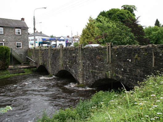
bridge — Virginia is recorded as bridge in Cavan. Triple-arch stone road bridge, dated 1894, spanning river flowing from north into Lough Ramor. Additional blocked-up arch to east end over mill race of adjacent former mill.
Why it was built
The saved account records: Spandrels and wing walls of coursed random rubble stone, upper sections re-laid and re-pointed, parapet rebuilt with Scotch coping.
People and work
The saved account records: Triple-arch stone road bridge, dated 1894, spanning river flowing from north into Lough Ramor.
How it changed
The saved account records: Additional blocked-up arch to east end over mill race of adjacent former mill.
What survives
The saved account records: Remains of pedestrian entrance in rendered wall at west end of south parapet with block-and-start ashlar sections.
Why it mattered
bridge — Virginia matters for the exact reasons given in its official assessment, rather than merely because it is an old structure. The source records: The bridge is a significant feature of the engineering and infrastructural heritage of the town. Coupled with the adjacent former mill and mill race, the bridge is part of a group which gives insight into the industrial history of the locality, using water power as a source of energy. Along with the mill, the bridge adds to the picturesque quality of the approach into Virginia. This explains what the place adds to local life, the street or the surviving built history.
History checked 15 August 2026 against the named sources below.
Places near here
- mill (water) — The Old Millbuildingunder 0.1 miles
- Location of National School Census 1821memorialunder 0.1 miles
- The Virginia Broochmonumentunder 0.1 miles
- Cois Abhainn — Bridge Terracebuildingunder 0.1 miles
- house — Bridge Terracebuildingunder 0.1 miles
- house — Main Streetbuildingunder 0.1 miles
- Ramor Theatre — Main Streetbuildingunder 0.1 miles
- Bank House — Main Streetbuildingunder 0.1 miles
- Virginia Old Graveyardmemorial0.1 miles
- Old milestone — N10019584369monument0.1 miles
- shop/retail outlet — Main Streetbuilding0.2 miles
- Welcome to Virginiaviewpoint0.2 miles
Add the human story, a picture, a first-hand message or a missing place.
Earn 5 points after the picture is checked and accepted.
Add a pictureAdd its storyTalk or ask a questionAdd a new placeThis official record and map point do not grant access. Most recorded buildings are privately owned; view them only from public ground unless the owner allows entry.
Conversation about this place
Questions and messages sit beneath the source record. They are checked before appearing.
No questions or messages yet.
Ask a question or join the conversation