What is recorded here
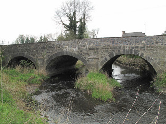
Bridge in Gransha More, at Latgallan, keeps one of its three arches dry in case the River Finn floods. It’s the good room of bridges: nobody in there till we have company, and God help us when that crowd arrives.
Triple-arch bridge, built c.1820, carrying road over River Finn. Segmental arches with dressed limestone voussoirs and squared stone soffits. Dry arch to west. U-plan dressed limestone cut-waters to each elevation, having tooled limestone capping. Piers and abutments reinforced with concrete. Coursed roughly squared rubble stone to spandrel and parapet walls, south parapet wall rebuilt. Tooled stone capping to parapets.
This well-designed and well-executed bridge is testament to the skill and craftsmanship of civil engineers and stonemasons in the early part of the nineteenth century, and is representative of the expansion in the road network at that time. Tooled stone detailing provides a contrast to the rubble stone of the spandrels and parapets, while U-plan cutwaters fulfil an aesthetic as well as a practical function in providing a sense of symmetry to each elevation. The dry arch is indicative of fore planning for potential floods, and the continued use of the site is a testament to the skill of nineteenth-century engineers.
From the Buildings of Ireland (National Inventory of Architectural Heritage) record 41401219
This does not grant access. Most recorded buildings are privately owned; view them only from public ground unless the owner allows entry.
Places near here
 mill (water)63 yd
 Stone Bridge Presbyterian ChurchChurch/chapel · 97 ydJaundice WellSpring · 1093 ydSaint John's WellSpring · 1.7 mi
 Common Lime1.8 mi
 Grave YardGraveyard · 2.1 miRoosky Castle (Site of)Castle, ringwork · 2.1 miLisarrilly HillMountain / peak · 2.6 mi
 CrossCross, High cross · 3.0 mi
 Abbey RuinsHeritage attraction · 3.0 mi
 The Cassandra Hand CentreMuseum · 3.1 mi
 European Yew5.8 mi
Pictures: National Inventory of Architectural Heritage; Kenneth Allen, Geograph · Creative Commons Attribution-ShareAlike 2.0; Alvesgaspar, Wikimedia Commons · CC BY-SA 3.0; Kieran Campbell, Geograph · Creative Commons Attribution-ShareAlike 2.0; Andreas F. Borchert, Wikimedia Commons · CC BY-SA 4.0; Simonchadwick1023, Wikimedia Commons · CC BY-SA 4.0; Kenneth Allen, Geograph · CC BY-SA 2.0; Sitomon, Wikimedia Commons · CC BY-SA 2.0
More historic places in County Monaghan · All of County Monaghan
What do you know about this place?