What is recorded here
In the grounds of Gulladoo House are three bridges. Two of them cross the River Bredagh which goes through a U-turn at this point. The river no longer passes under the third bridge. This was pointed out to us as the 'Old Bridge' which previous authorities had attributed to the sixth, eight or ninth centuries (Swan…
Read the whole record
From the National Monuments Service (Archaeological Survey of Ireland) record DG021-009
Places near here
Photo credits
- National Inventory of Architectural Heritage
- Kenneth Allen, Geograph · CC BY-SA 2.0
- Oliver Dixon, Wikimedia Commons · CC BY-SA 2.0
- Andreas F. Borchert, Wikimedia Commons · CC BY-SA 4.0
- Attila Terbócs, Wikimedia Commons · CC BY-SA 3.0
- Patrick Mackie, Geograph · CC BY-SA 2.0
- Corinna Schleiffer, Wikimedia Commons · CC BY-SA 2.0
- MoorsoP, Wikimedia Commons · CC BY-SA 4.0
 bridge8 yd
Explorer Tom Bridge in Glencrow has been arching over the Bredagh Glen River since around 1600. Its invisible stone hat is ready for traffic on the Gulladuff House avenue. Holding up that road is a long job.
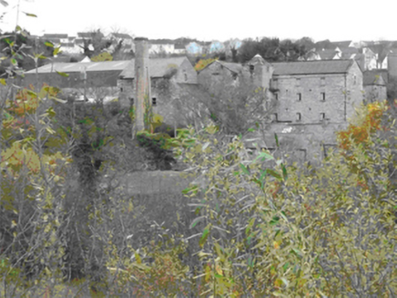 Gulladoo MillMill (water) · 130 yd
Explorer Tom Gulladoo Mill is a massive corn-crunching beast from 1811 that used to power itself with river water. It’s basically an industrial giant now sleeping in Goladoo, looking all smug about its complex multi-storey layout and questionable plumbing history.
 Rosato’sPub · 396 yd
Explorer Tom Rosato’s is on Malin Road, which sounds like a road specifically designed for people who are completely lost. Tell them Tom sent you and expect a stare that could peel paint off the walls. Pretend you're a lost aristocrat, nobody will check.
 Maguire’sPub · 429 yd
Explorer Tom Maguire’s is basically next door to Susie’s on Main Street, creating a double-header of local gossip that never sleeps. Take notes before you forget who said what about whom. Sit on a wall and pretend you're in a painting.
 Bath GreenPark · 669 yd
Explorer Tom Bath Green sounds like a splashy name for a quiet park, making me wonder if it hides some hidden water feature.
 Cooly Medieval GraveslabGraveslab · 1066 yd
Explorer Tom Cooly Medieval Graveslab is tucked just metres from the Skull House, which sounds far more dramatic than it likely was. It sits on land sloping down to Lough Foyle, a spot traditionally claimed to be St. Patrick’s own founding project. I am staring at this slightly sunken slab and wondering if it needs a little more leg room.
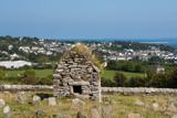 Skull HouseShrine · 1068 yd
Explorer Tom Skull House is a tiny, gabled tomb that looks like it’s guarding a secret. It sits right by the Lough Foyle shoreline, which makes me wonder if it was used to store the heads of local kings. Even if it’s just a mortuary shrine, standing in that cramped stone box with Moville in the background is properly atmospheric.
 Cooley CrossMemorial · 1126 yd
Explorer Tom Cooley Cross in County Donegal stands tall near Moville, probably judging your outfit as you pass by. It’s got that solemn vibe that makes you want to whisper instead of talk. Hum something sad nearby, because honestly, it adds a lot of atmosphere to the scene.
 CrockaulinMountain / peak · 2.3 mi
Explorer Tom Crockaulin offers a lonely triangulation pillar that stares down at Greencastle from a dizzying height. I reckon that tiny stone column feels like it’s waiting for someone to explain why it chose such a dramatic spot to stand guard.
 Inishowen Maritime Museum and PlanetariumMuseum · 2.5 mi
Explorer Tom Inishowen Maritime Museum and Planetarium puts the sea and sky under one old Coast Guard roof in Greencastle. I would happily spend a day moving from fishing boats to the stars. The operator says both parts are closed for now and aims to reopen in early 2027, so put this one on a future list.
 CrockavishaneMountain / peak · 2.6 mi
Explorer Tom Crockavishane in Donegal is having a very fancy lunch experience that costs nothing but your dignity. It’s all about the ambiance of doing absolutely nothing productive. Have a sandwich here and call it a heritage lunch.
 GreencastleCastle · 3.0 mi
Explorer Tom Greencastle was built in 1305 to hold down the North West. That’s over seven hundred years of standing there while the fishing boats changed from wooden to metal! I bet it’s still listening for the clank of old swords.
More historic places in County Donegal · All of County Donegal

What do you know about this place?Tap to add a comment or ask a question