
What is recorded here
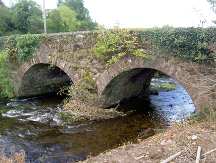
Double-arch road bridge over Owenbaun River, built c. 1850, having limestone V-cutwaters to west elevation. Roughly dressed sandstone walls with rendered copings to the parapet walls. Roughly dressed sandstone voussoirs to round arches.
Bride's Bridge is a well-designed structure, indicative of the skill of early nineteenth-century craftsmen and engineers. The cutwaters add decorative interest to the west elevation. The rendered copings add interest to the parapet walls.
From the Buildings of Ireland (National Inventory of Architectural Heritage) record 20903908
This does not grant access. Most recorded buildings are privately owned; view them only from public ground unless the owner allows entry.
Places near here
Photo credits
- National Inventory of Architectural Heritage
- Maker shown on the Wikimedia Commons file page · CC BY-SA 3.0
- Jonathan Thacker, Geograph · Creative Commons Attribution-ShareAlike 2.0
- Mike Searle, Wikimedia Commons · CC BY-SA 2.0
- Jonathan Thacker, Geograph · CC BY-SA 2.0
- Jonathan Thacker, Wikimedia Commons · CC BY-SA 2.0
- Colin Park, Geograph · Creative Commons Attribution-ShareAlike 2.0
- Eeno11, Wikimedia Commons · CC BY-SA 3.0
 Rathcool BridgeBridge · 805 ydRathcool WoodWood · 831 yd
 Lyon's BridgeBridge · 1153 yd
 Battle of KnocknaclashyBattle · 1.5 mi
 Grave YardGraveyard · 3.2 mi
 Castle and TurretCastle, tower house · 3.3 mi
 St. Patrick's ChurchVisitor information · 4.5 mi
 MusheraMountain / peak · 4.7 mi
 Holy Well4.8 mi
 Rowan5.0 mi
 Mount Hillary - Father Murphy LoopWalking route · 5.1 mi
 Kilmeedy CastleCastle, tower house · 5.6 mi
More historic places in County Cork · All of County Cork
What do you know about this place?