
What is recorded here
From OpenStreetMap (© OpenStreetMap contributors) n2122930886
Places near here
Picture notes
- Computer-made picture. It does not show this mountain top.
- Computer-made picture. It does not show this monument.
- kevin higgins, Wikimedia Commons · CC BY-SA 2.0
- National Inventory of Architectural Heritage
- Donald Hobern from Copenhagen, Denmark, Wikimedia Commons · CC BY 2.0
- Humphrey Bolton, Geograph · Creative Commons Attribution-ShareAlike 2.0
- Lisamoriarty1, Wikimedia Commons · CC BY-SA 4.0
- A.-K. D., Wikimedia Commons · CC BY-SA 4.0
- Mike Searle, Wikimedia Commons · CC BY-SA 2.0
- Computer-made picture. It does not show this walking route.
 Ballycronigan RockMountain / peak · 273 ydComputer-made picture
Explorer Tom Ballycronigan Rock sounds like a tough one! It's a peak in Carlow, and I bet it offers some great views for the adventurous.
 Hut site in BallycrinniganHut site · 464 ydComputer-made picture
Explorer Tom Hut site in Ballycrinnigan has a hidden treasure that’s definitely a biscuit tin from the eighties. It’s got only two walls visible, so it’s basically a closet with commitment issues. Bring someone who'll believe anything you say about finding gold coins.
 CairnCairn, unclassified · 470 ydComputer-made picture
Explorer Tom This Cairn is sitting right on top of a field wall in Ballycrinnigan, which is just lazy architecture. It’s basically a stone pile that couldn’t be bothered to find its own foundation. Bring your worst joke, the place has heard worse from the sheep.
 Bran PoceaghMountain / peak · 1045 ydComputer-made picture
Explorer Tom Bran Poceagh is a peak in County Carlow; the name makes me think of ancient, mossy stones and secret fairy forts nearby.
 Marley BridgeBridge · 2.2 mi
Explorer Tom Marley Bridge is a single-arch granite bridge over a railway line, built in 1865 to look important. One parapet was removed recently, probably because it was causing traffic delays. Best visited with a curious kid and no timetable.
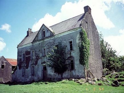 Knockduff HouseHouse · 2.5 mi
Explorer Tom Knockduff House is telling its younger self to stop worrying about the pediment because the joinery is still there anyway. It’s a sturdy 1750 house that has seen better days and worse sandwiches. Have a sandwich here and call it a heritage lunch.
 Silver Wattle2.9 mi
Explorer Tom Silver Wattle in County Carlow has strict rules: no screaming, no bad puns, and definitely no touching the bark without asking. It's all about manners out here. Stand there long enough and someone will ask if you're lost or just shy.
 Graveyard in St. Mullin'sGraveyard · 3.2 mi
Explorer Tom Graveyard in St. Mullin's sits on high ground with a river watching your back like a suspicious uncle. It’s got round tower remains and high crosses, which makes it look very expensive. Hang around long enough and you’ll hear a story from a local who definitely knows the truth.
 St. Mullins MoatCastle, motte and bailey · 3.2 mi
Explorer Tom St. Mullins Moat is a hill that got rich and moved out. It’s secretly proud of the potato it grew on its shoulder. Walk past slowly like you're in a film.
 The SpoutSpring · 3.8 mi
Explorer Tom The Spout has caught my eye in County Kilkenny. I bet a spring with a name like that could keep me talking all afternoon; I'm already inventing a daft little scene for it, and I'll stop before it turns into history.
 Coolhill Castle (in ruins)Castle, tower house · 4.0 mi
Explorer Tom Coolhill Castle has caught my eye in Coolhill, County Kilkenny. I bet a castle, tower house with a name like that could keep me talking all afternoon; I'm already inventing a daft little scene for it, and I'll stop before it turns into history.
 Brandon Hill LoopWalking route · 4.9 miComputer-made picture
Explorer Tom Brandon Hill Loop has caught my eye in County Kilkenny. I bet a walking route with a name like that could keep me talking all afternoon; I'm already inventing a daft little scene for it, and I'll stop before it turns into history.
More mountains and hills in County Carlow · All of County Carlow

What do you know about this place?Tap to add a comment or ask a question