
Places near here
Photo credits
- kevin higgins, Wikimedia Commons · CC BY-SA 2.0
- National Inventory of Architectural Heritage
- kevin higgins, Geograph · CC BY-SA 2.0
- Donald Hobern from Copenhagen, Denmark, Wikimedia Commons · CC BY 2.0
- A.-K. D., Wikimedia Commons · CC BY-SA 4.0
- Humphrey Bolton, Geograph · Creative Commons Attribution-ShareAlike 2.0
- Sarah777, Wikimedia Commons · CC BY-SA 3.0
- Lisamoriarty1, Wikimedia Commons · CC BY-SA 4.0
- Mike Searle, Wikimedia Commons · CC BY-SA 2.0
- Colin Park, Geograph · CC BY-SA 2.0
 Marley BridgeBridge · 2.1 mi
Explorer Tom Marley Bridge is a single-arch granite bridge over a railway line, built in 1865 to look important. One parapet was removed recently, probably because it was causing traffic delays. Best visited with a curious kid and no timetable.
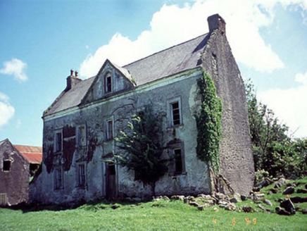 Knockduff HouseHouse · 2.5 mi
Explorer Tom Knockduff House is telling its younger self to stop worrying about the pediment because the joinery is still there anyway. It’s a sturdy 1750 house that has seen better days and worse sandwiches. Have a sandwich here and call it a heritage lunch.
 SlievebaunMountain / peak · 2.7 mi
Explorer Tom Slievebaun is hiding a scandal involving a lost hat and a very angry vicar from 1720. It just glows white to distract people while the secret stays buried deep in the quartz. Go on, count the windows and get it wrong like I did.
 Silver Wattle3.5 mi
Explorer Tom Silver Wattle in County Carlow has strict rules: no screaming, no bad puns, and definitely no touching the bark without asking. It's all about manners out here. Stand there long enough and someone will ask if you're lost or just shy.
 St. Mullins WellHoly well · 3.6 mi
Explorer Tom St. Mullins Well is dry as a bone, which is rude for a holy water source. It’s basically a stone cup with no drink, so tell the kids it's a castle. Close enough to make them stop squirming.
 Graveyard in St. Mullin'sGraveyard · 3.6 mi
Explorer Tom Graveyard in St. Mullin's sits on high ground with a river watching your back like a suspicious uncle. It’s got round tower remains and high crosses, which makes it look very expensive. Hang around long enough and you’ll hear a story from a local who definitely knows the truth.
 St. MullinsHistoric town · 3.6 mi
Explorer Tom St. Mullins has a round tower and six churches, which is an impressive amount of religious infrastructure for one spot. Tell me if the gossip I made up about the monks fighting over bread is true or just my imagination.
 St. Mullins MoatCastle, motte and bailey · 3.7 mi
Explorer Tom St. Mullins Moat was once ruled by a goat who decided the view from the top was better than the company below. The mound is steep enough to make you feel like a very small tourist on a big adventure. Bring your own legend, I've run out.
 The SpoutSpring · 4.2 mi
Explorer Tom The Spout in Ballinvarry has lost its actual spout part, which is like losing your nose but keeping the rest of your face, so it’s just a very confused water source now. Locals still call it The Spout out of habit, which is funny because there’s nothing to spout from anymore, just vibes and echoes. If it's closed, admire it from the road like a polite stalker.
 Coolhill Castle (in ruins)Castle, tower house · 4.6 mi
Explorer Tom Coolhill Castle is a circular tower on a steep precipice, looking very smug about it. Its first owner’s escape plan was probably just 'run really fast'. Get a photo with it before it gets a better agent.
 The Barrow WayVisitor information · 4.8 mi
Explorer Tom The Barrow Way thinks Dublin tourists are just people who forgot their sense of direction and their manners on the train. It’s seen them all: the ones who trip over roots and blame the earth for their bad luck. Linger, it's not going anywhere and neither should you.
 St. Michaels Church (in Ruins), GraveyardChurch · 5.0 mi
Explorer Tom St. Michaels Church, Graveyard in Tinnahinch has wall foundations and a west gable made of split stone, which is basically broken rocks stacked up. An altar was erected there in 1989, so someone still cares about the vibe. Spot the oldest stone and give it a name.
More mountains and hills in County Carlow · All of County Carlow

What do you know about this place?Tap to add a comment or ask a question