What is recorded here
From the National Monuments Service (Archaeological Survey of Ireland) record RO005-003
Places near here
Photo credits
- Gavigan 01 at English Wikipedia, Wikimedia Commons · CC BY 2.5
- Oliver Dixon, Geograph · CC BY-SA 2.0
- Daniel Waters, Co. Sligo, Ireland from Ireland, Wikimedia Commons · CC BY 2.0
- National Inventory of Architectural Heritage
- Joseph Mischyshyn, Wikimedia Commons · CC BY-SA 2.0
- Wikimedia Commons contributor · CC BY 2.5
- abdallahh from Montréal, Canada, Wikimedia Commons · CC BY 2.0
- Stephan van Helden, Wikimedia Commons · CC BY-SA 4.0
- Rob Hurson, Wikimedia Commons · CC BY-SA 4.0
 Battle of the Curlew Mountains (1599)Battlefield · 583 yd
Explorer Tom The Battle of the Curlew Mountains has a family tree consisting entirely of angry men with sticks and bad decisions. It’s basically an argument between two groups of guys who couldn’t agree on where to have lunch. Grand place for a sulk or a snog, completely your call.
Battle of the Curlew MountainsBattlefield · 591 ydExplorer Tom Battle of the Curlew Mountains is where a dog named Buster is currently in charge, barking orders at the clouds and the sheep alike. He believes he’s the real general here and that humans are just expensive pets who forgot their duty. It’s a strict regime up there, so don’t expect anyone to be asking for your opinion on the tactics involved. Make up your own legend and I'll swear it's true.
 Saint Beaidh's Church (Ardcarne)Church/chapel · 1.8 mi
Explorer Tom Saint Beaidh's Church (Ardcarne) in Knocknashee is where map makers got confused, probably because the church kept moving to dodge the surveyors. It sits there looking stark and impoverished, like it’s been waiting for someone to bring it some decent gardening tips since 1800. Gaze at the tower; it might just shrug back.
 Ballinafad CastleCastle · 1.8 mi
Explorer Tom Ballinafad Castle in County Sligo has strict house rules that include no shoes, no talking, and definitely no asking why it looks so confused on the map. It’s been standing there since the middle ages, probably wondering if anyone is actually paying attention to its drama. It's free, it's odd, what more do you want?
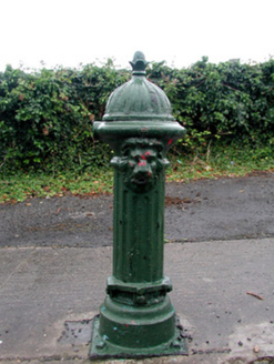 Historic buildingOfficially recorded historic building · 1.9 mi
Explorer Tom Historic building in Mocmoyne is actually just a fancy water pump that thinks it’s a piece of art because it has an acorn on top. It used to be the center of town gossip, back when people had to walk over there just to get a drink instead of using the tap. Now it’s basically a statue with a bit more dignity than most garden ornaments.
 Boyle AbbeyVisitor attraction · 2.1 mi
Explorer Tom Boyle Abbey has a hidden message in its stones that just says 'get out' if you stand there long enough to decode it properly. Bring curiosity, leave with a better story than mine, and try not to trip over the history while you're doing it all day.
 Hog's IslandIslet · 2.3 mi
Explorer Tom Hog’s Island in County Roscommon sounds like the place where pigs go to hide from the butcher, but it’s probably just a rock. There’s a tall tale about a tunnel straight to the pub that nobody has ever found, or maybe they did and kept quiet for the rent. Look for the ghost, then pretend you didn't.
 Curlew MountainsMountain / peak · 2.8 mi
Explorer Tom Curlew Mountains would survive a zombie attack by simply standing still and letting them trip over its rocks, then laughing internally. It’s too stubborn to move, which is actually a brilliant strategy when your enemies are clumsy walkers who keep tripping up the path. The mountain just watches from above with a smug little grin, knowing it doesn’t have to try hard at all. Pack a picnic and an
 Western Redcedar3.3 mi
Explorer Tom Western Redcedar in County Roscommon would want 'Finally Tall Enough' on its tombstone because it spent centuries growing only to be outdone by the clouds, which is a tragedy that really sticks in the ribs of any ambitious conifer with big dreams. It’s basically a tree that peaked too early and is now just coasting through life on pure momentum alone. Tell the kids it's a castle. Close enough.
 Horse-chestnut3.5 mi
Explorer Tom Horse-chestnut in County Roscommon was once a matchmaker for local couples who wanted to prove their love was as strong as its fruit. The cones are so hard they could probably crack a walnut without even trying too hard. Bring a flask of something warm and a story to swap.
 Loughbrick BayBay · 4.1 mi
Explorer Tom Loughbrick Bay in County Sligo would tell you after a few pints that it actually swallowed a boat once but gave it back because it didn’t taste right, which is plausible. The water has a certain confidence about it, like it knows exactly where the bottom is and isn’t telling anyone else. Bring sandwiches, the gulls will thank you.
 Bricklieve MountainsMountain / peak · 4.4 mi
More historic places in County Roscommon · All of County Roscommon

What do you know about this place?Tap to add a comment or ask a question