What is recorded here
In pasture, at the base of a NE-facing slope. A circular area (10.4m N-S; 10.8m E-W) enclosed by a fosse (D 0.3m; Wth 2.6m base) with an external earthen bank (int. H 0.45m; ext. H 0.15m). Both fosse and bank are truncated WNW->N by a field boundary. The outer edge of the bank clipped by a stream N->ENE. The level interior is under pasture.
From the National Monuments Service (Archaeological Survey of Ireland) record LI028-155
The monument record does not grant public access. Check the route and ask the landowner before entering private land.
- What survives
- Recorded monument
Places near here
Photo credits
- National Inventory of Architectural Heritage
- Mike Searle, Geograph · CC BY-SA 2.0
- Willow, Wikimedia Commons · CC BY 2.5
- Created by Kglavin Modified Aug 2007 by Mike Christie, Wikimedia Commons · CC BY-SA 3.0
- A.-K. D., Wikimedia Commons · CC BY-SA 4.0
- Vadim Manuylov, Wikimedia Commons · CC BY-SA 3.0
 Reens HouseHouse · 260 ydEnclosure in CoolanoranEnclosure · 924 yd
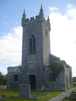 Kilscannell ChurchChurch/chapel · 1119 yd
 Elm HillCountry house · 1.0 mi
 bridge1.1 miSt. Kieran's WellSpring · 1.2 mi
 European ash1.9 mi
 Castle MatrixCastle · 2.4 mi
 Castle MatrixCastle, tower house · 2.4 mi
 Ardagh FortArchaeological place · 2.9 mi
 Saint Ite's WellSpring · 8.4 mi
 Monterey Cypress9.9 mi
More archaeology and monuments in County Limerick · All of County Limerick
What do you know about this place?