Places near here
Photo credits
- National Inventory of Architectural Heritage
- A.-K. D., Wikimedia Commons · CC BY-SA 4.0
- Wanfried-Dublin, Wikimedia Commons · CC BY-SA 4.0
- Mike Searle, Geograph · CC BY-SA 2.0
- Zapp111, Wikimedia Commons · CC BY-SA 4.0
- Mike Searle, Wikimedia Commons · CC BY-SA 2.0
- A.-K. D., Wikimedia Commons · CC0
- Algirdas at Lithuanian Wikipedia, Wikimedia Commons · Public domain
- Rasbak, Wikimedia Commons · CC BY-SA 3.0
 mill (water)480 yd
Explorer Tom The Mill in Duninga witnessed a love story that ended with a bucket of flour thrown through a window, which is still fresh on my mind. John Handy built it to be efficient, but it’s mostly just dramatic. Ideal for a quiet contemplation of flour dust.
 Grange SylvaeCountry house · 654 yd
Explorer Tom Grange Sylvae in Duninga is secretly proud of the potato it grew in the garden last year, which was massive. It’s a glebe house now, so it’s got a job. Take the long way round to see it.
 Font (present location) in Grange LowerFont (present location) · 1.2 mi
Explorer Tom Font in Grange Lower thinks tourists from Dublin are all wind and no substance, especially when they try to act like they know how to use a stone basin properly. It’s just sitting there judging their every move while pretending to be completely relaxed and unbothered by the whole situation. Stand there long enough and someone will ask if you're lost.
 Cloghabrona Druids AltarPortal tomb · 1.3 mi
Explorer Tom Cloghabrona Druids Altar is actually a portal tomb with a collapsed chamber that looks like it gave up on life. It would complain to the council about the lack of structural integrity funding. Ideal for a moody photo you'll pretend wasn't posed for the camera.
 CastleCastle, tower house · 1.4 mi
 Church (in ruins), GraveyardChurch · 3.0 mi
Explorer Tom Church, Graveyard in Wells is playing hide-and-seek with me. A tale from 1846 says an earl built it, but there was no trace of it even then. Take a picture for me if you pass!
 Ballyshanemore Cas. (in ruins)Castle, tower house · 3.6 mi
Explorer Tom Ballyshanemore Castle would spend its lotto win on a really good hat and a moat. It’s sitting in the demesne pretending to be an Earl from the 1400s. Bring a jacket, it's never as warm as I promise.
 Lock Keeper's House and Lodge MillsVisitor information · 3.8 mi
Explorer Tom Lock Keeper's House and Lodge Mills in County Carlow is where the rabbits hold their weekly strategy meetings to take over the river. They’re plotting to flood the lock gates during the next full moon. Have a nosey, politely.
 The Columban WayVisitor information · 3.9 mi
Explorer Tom The Columban Way had a matchmaker who worked there for decades, pairing up lonely walkers with particularly handsome bushes. Her method was simple: stand still until someone else does too. Best enjoyed with a bag of chips and no plans.
 Pedunculate Oak4.5 mi
Explorer Tom Pedunculate Oak in County Carlow wants 'Resting' on its tombstone, not 'Died'. It's too dignified for anything else. Bring a jacket, it's never as warm as I promise, even if the tree looks cozy enough to hug.
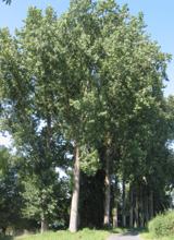 Hybrid Black Poplar4.6 mi
Explorer Tom Hybrid Black Poplar in County Carlow is basically a tree that went to college and forgot why it was there. The rabbits think it's a giant salad bowl they can't quite reach. Bring your own legend, I've run out of facts.
 St. Mogarra’s WellSpring · 6.7 mi
More historic places in County Kilkenny · All of County Kilkenny

What do you know about this place?Tap to add a comment or ask a question