
What is recorded here
From the Buildings of Ireland (National Inventory of Architectural Heritage) record 12402106
Places near here
Photo credits
- Maker not stated on source page, ru.pinterest.com
- National Inventory of Architectural Heritage
- Maker not stated on source page, www.visitgalway.ie
- Artur Kozioł, Wikimedia Commons · CC BY-SA 3.0
- A.-K. D., Wikimedia Commons · CC BY-SA 4.0
- Maker not stated on source page, www.bigstockphoto.com
- Maker not stated on source page, commons.wikimedia.org
 Duninga GraveyardCemetery · 818 yd
Explorer Tom Duniga Graveyard is currently being evaluated by a colony of rabbits who think the headstones are excellent scratching…
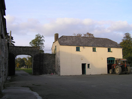 Barraghcore HouseFarmyard complex · 1033 yd
Explorer Tom Barraghcore House in Duninga is sick of people asking if the cows live there too, because apparently some folks need…
 Castlekelly Castle (site of)Archaeological place · 1042 yd
Explorer Tom Castlekelly Castle in County Kilkenny is planning its retirement by slowly turning into a nice-looking pile of rocks.…
 farm house1135 yd
Explorer Tom Farm house in Bohernastrekaun had an escape plan involving a goat and a ladder that never quite worked out as intended.…
 mill (water)1249 yd
Explorer Tom The Mill in Duninga witnessed a love story that ended with a bucket of flour thrown through a window, which is still…
 Upper Ballyellin LockLock · 1506 yd
Explorer Tom Upper Ballyellin Lock has replacement gates from 1990 sitting on top of 1790 foundations, which is just architectural…
 Grange SylvaeCountry house · 1509 yd
Explorer Tom Grange Sylvae in Duninga is secretly proud of the potato it grew in the garden last year, which was massive. It’s a…
 Font (present location) in Grange LowerFont (present location) · 1734 yd
Explorer Tom Font in Grange Lower thinks tourists from Dublin are all wind and no substance, especially when they try to act like…
 Saint George's Church (Grangesilvia)Church/chapel · 1738 yd
Explorer Tom Saint George's Church in Grangesilvia thinks the shortcut through its graveyard is actually the long way round, so it…
 Mapped graveyardGraveyard · 1.1 mi
Explorer Tom Another Mapped graveyard in County Kilkenny gets picked on by the wind because its fence is slightly crooked and very…
 Lady WellWell · 1.2 mi
Explorer Tom Lady Well in Grange Lower has an oratory next to it, which is fancy for a well. It would say 'I’m not dry, I’m…
 Lord Galmoy's castle (site)Archaeological place · 1.3 mi
Explorer Tom Lord Galmoy's castle in County Kilkenny would last about three episodes on a reality show before someone dropped a…
More historic places in County Kilkenny · All of County Kilkenny

What do you know about this place?Tap to add a comment or ask a question