What is recorded here
Listed as 'Village' in the Dublin Record of Monuments and Places issued in 1998 when it was assigned the RMP No. DU005-057----. This classification has been changed to Settlement Cluster as it relates to the settlement or village of Balrothery which was clustered around Balrothery Church (DU005-057003-), graveyard (DU005-057005-), Balrothery Castle (DU005-057006-) and the triangular shaped Fair Green located to the NE of the graveyard. The terrier of the 1657 Down Survey map of the parish of Balrothery recorded that Patrick Barnewell was the owner of ‘Severall Tenements undistinguished’ in the townland of 'Balrudery'. According to Lewis (1837, 170-1) the church of Balrothery was ‘anciently annexed to that part of the church of Lusk which in the earlier ages belonged to the archdeaconry of Dublin, and was separated from it about the year 1220 by Archbishop Henry. The village is situated on the road from Dublin to Balbriggan, from which latter it is distant about a mile, and in 1831 contained 84 houses’ (ibid.). He also recorded the local tradition that ‘Jas. II. is said to have slept at the White Hart Inn here, before the battle of the Boyne: and the same distinction is claimed by another ancient house in the village, which was formerly an extensive inn’ (ibid.). Two fairs were held at Balrothery on the 6th of May and the 12th of August for the sale of ‘Cattle and Pedlar’s goods’ (Carlisle 1810).
Listed as 'Village' in the Dublin Record of Monuments and Places issued in 1998 when it was assigned the RMP No. DU005-057----. This classification has been changed to Settlement Cluster as it relates to the settlement or village of Balrothery which was clustered around Balrothery Church (DU005-057003-), graveyard (DU005-057005-), Balrothery Castle (DU005-057006-) and the triangular shaped Fair Green located to…
From the National Monuments Service (Archaeological Survey of Ireland) record DU005-057
The monument record does not grant public access. Check the route and ask the landowner before entering private land.
- What survives
- Recorded monument
Places near here
Photo credits
- National Inventory of Architectural Heritage
- Jonjobaker, Wikimedia Commons · CC BY-SA 4.0
- Offdaw, Wikimedia Commons · CC BY-SA 4.0
- GsmithEIDW at English Wikipedia, Wikimedia Commons · Public domain
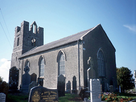 Saint Peter's Church (Balrothery)Church/chapel · 95 yd
 Balrothery Heritage CentreMuseum · 96 yd
 Church in BalrotheryChurch · 109 yd
 Balrothery TowerCastle · 111 ydField system in Glebe SouthField system · 163 ydFlat cemetery in DarcystownFlat cemetery · 497 ydWavin LakesNature reserve · 900 ydCastle (remains of)Castle, tower house · 1390 ydBarn WoodWood · 1631 yd
 Ardgillan CastleHeritage attraction · 1.2 miBbq AreaPicnic place · 1.2 mi
 Martello Tower2.0 mi
More archaeology and monuments in County Dublin · All of County Dublin
What do you know about this place?