
What is recorded here
Situated on the S bank of the meandering Nanny Water c. 100m SW of a loop in the river, and c. 2km from where it enters the Irish Sea. According to the Civil Survey (1654-6) Lord Netterville of Ballygarth owned 348 acres at Ballygarth and Corballis in 1640, amounting to the whole parish, and the property included ‘one…
Read the whole record
From the National Monuments Service (Archaeological Survey of Ireland) record ME028-002
Places near here
Photo credits
- Kieran Campbell, Geograph · CC BY-SA 2.0
- Maker not stated on source page, www.pinterest.com
- Maker not stated on source page, www.rte.ie
- Offdaw, Wikimedia Commons · CC BY-SA 4.0
- National Inventory of Architectural Heritage
- Kieran Campbell, Wikimedia Commons · CC BY-SA 2.0
- Maker not stated on source page, www.dreamstime.com
 Church in BallygarthChurch · 97 yd
Explorer Tom Church in Ballygarth sits on a rise above the River Nanny, which is just a stream pretending to be bigger. It’s not…
 Graveyard in BallygarthGraveyard · 97 yd
Explorer Tom Graveyard in Ballygarth is just a family burial ground for the Peppards since the 1650s, which makes it sound like a…
 St. Marys ChurchChurch · 835 yd
Explorer Tom St. Marys Church in Julianstown West is perched on that plateau acting all superior, probably listening to the seagulls…
 TombTomb, chest tomb (present location) · 835 yd
Explorer Tom Tomb in Julianstown West has an Apostle Stone that looks like someone gave up halfway through carving. The saints have…
 Saint Mary's Church (Julianstown)Church/chapel · 836 yd
Explorer Tom Saint Mary's Church in Julianstown had a cow that tried to buy it with a cartload of cabbages. The stained glass is…
 Julianstown HouseFarm house · 890 yd
Explorer Tom Julianstown House in Julianstown West, County Meath has got the seagulls arguing about whose turn it is to steal a…
 Battle of JulianstownBattle · 945 yd
Explorer Tom Battle of Julianstown in County Meath is having a massive go at winning the county fair prize for 'Most Dramatic Mud…
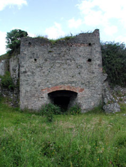 kiln1082 yd
Explorer Tom Kiln in Julianstown West, County Meath would order extra thick chips and no ketchup if it had hands. It sat by the…
 bridge1168 yd
Explorer Tom Bridge in Dimanistown East hosted a dance in 1841 that definitely went too far with the government troops. It’s still…
Battlefield in Ballygarth,dalystown,dimanistown East,dimanistown West,julianstown West,smithstown (duleek Lower By.)Battlefield · 1407 ydExplorer Tom Battlefield in Ballygarth is giving up its ancient secrets for Lent, which feels like a massive personal insult to…
 CrossCross, Wayside cross · 1.4 mi
Explorer Tom Cross in Sarsfieldstown is stuck in a garden like an awkward uncle at a wedding. It’s got a Pietá that looks deeply…
 Mapped cemeteryCemetery · 1.6 mi
Explorer Tom Mapped Cemetery insists that the shortcut through the middle is actually the longest way around if you take the scenic…
More castles and forts in County Meath · All of County Meath

What do you know about this place?Tap to add a comment or ask a question