What is recorded here
From OpenStreetMap (© OpenStreetMap contributors) n13114859534
Places near here
Picture notes
- Graham Horn, Wikimedia Commons · CC BY-SA 2.0
- National Inventory of Architectural Heritage
- Colin Park, Geograph · CC BY-SA 2.0
- Hello, I am Bruce on Flickr, Wikimedia Commons · CC BY-SA 2.0
- Computer-made picture. It does not show this garden.
- Maker named on the Wikimedia Commons picture page · Public domain
- liam murphy, Geograph · Creative Commons Attribution-ShareAlike 2.0
- liam murphy, Geograph · CC BY-SA 2.0
- Mronan087, Wikimedia Commons · CC BY-SA 4.0
- Computer-made picture. It does not show this playground.
 Catholic Church of Saint Peter and Saint PaulChurch/chapel · 385 yd
Explorer Tom Perched on Ballon Hill, this cruciform church retains three galleries and a Gothic reredos from its construction around 1820.
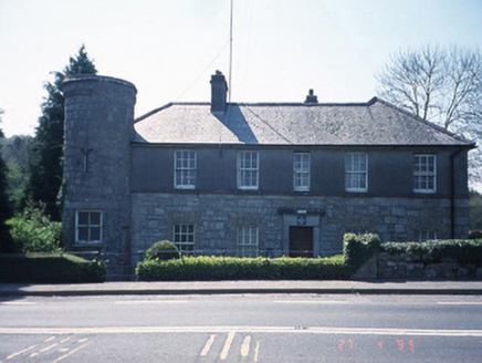 Ballon Garda Síochána StationRic barracks · 556 yd
Explorer Tom Ballon Garda Síochána Station has a corner tower on a circular plan, so it feels like standing guard over the whole of County Carlow.
 Castlegrace MoatCastle, motte · 1.6 mi
Explorer Tom This Castlegrace Moat is a large gravel mound, possibly partly natural, which was severely truncated on the south side in the 1970s.
 Altamont Gardens MapVisitor information · 2.3 mi
Explorer Tom Use the Altamont Gardens Map to navigate the flower borders near Kilbride, Co Carlow, as shown in local photos.
 Scots Pine2.4 mi
Explorer Tom This Scots Pine stands tall and proud, likely keeping watch over County Carlow from its high, needle-covered perch.
 Walled GardenGarden · 2.4 miComputer-made picture. It does not show this garden.
Explorer Tom Walled Garden in County Carlow is playing hide-and-seek with me. A gardener once claimed his tomatoes could tell him the truth about his love life, which was very inconvenient.
 English holly2.9 mi
Explorer Tom An English holly stands sharp and bright, probably guarding the area with its prickly, festive green determination.
Ballynunnery Castle in ruinsCastle, unclassified · 3.2 miExplorer Tom Ballynunnery Castle in ruins has a standing tower section with thick walls, offering a tangible connection to its past defensive structure here.
 Graveyard3.2 mi
Explorer Tom Graveyard in Ardristan is square-shaped with a church roughly centrally placed; I imagine it as a quiet, contemplative space surrounded by the gentle Irish countryside.
 Church (in ruins), GraveyardChurch · 3.3 mi
Explorer Tom Templepeter’s church remains include a fifteenth-century octagonal font and a grave-slab with a cross, nestled securely within its surrounding graveyard.
 St. Bridgets WellHoly well · 3.8 mi
Explorer Tom St Brigid's Well is now a modern shrine in the graveyard, so let's tip our hats to the saint.
 Children's playground3.8 miComputer-made picture. It does not show this playground.
Explorer Tom A Children's playground in County Carlow, where I imagine tiny boots stomping enthusiastically on the fresh grass.
More mountains and hills in County Carlow · All of County Carlow
What do you know about this place?Tap to add a comment or ask a question