Overview
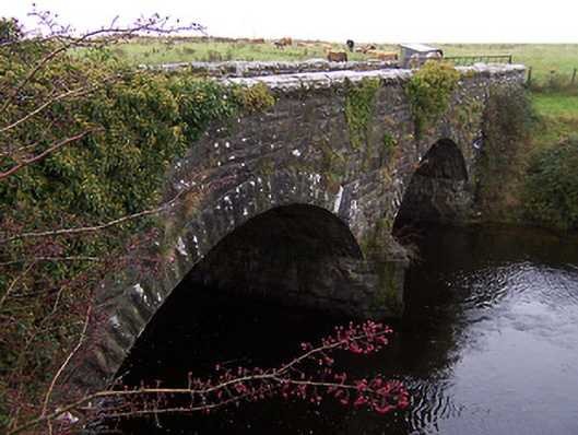
Ballinalack Bridge is recorded as bridge in Westmeath. Twin-arched road bridge over River Inny, dated 1874. Now out of use and superceded by a modern bridge to the south.
Why it was built
The saved account records: Constructed of coursed squared limestone rubble with rusticated rock-faced limestone voussoirs to arches and rusticated limestone copping over parapet.
People and work
The saved account records: Twin-arched road bridge over River Inny, dated 1874.
How it changed
The saved account records: Now out of use and superceded by a modern bridge to the south.
What survives
The saved account records: Projecting V-profile cut water to central pier.
Why it mattered
Ballinalack Bridge matters for the exact reasons given in its official assessment, rather than merely because it is an old structure. The source records: A robustly-built and substantial road bridge, which is a pleasing and distinct feature in the rural landscape. The good quality rusticated masonry is a typical feature of the many bridges built by Board of Works in the mid-to late nineteenth-century, suggesting that the board were responsible for the construction of this handsome structure. This bridge replaced an earlier five arch bridge located at this site, at a time when the River Inny was considerably wider at this point (Ordnance Survey Map 1838; Lewis 1837). Ballinalack Bridge is an important element of the civil engineering Heritage of County Westmeath… This explains what the place adds to local life, the street or the surviving built history.
History checked 15 August 2026 against the named sources below.
Places near here
- Ballinalack Br. — Ballinalackmonumentunder 0.1 miles
- Outlined — Ballinalackcastleunder 0.1 miles
- Castle — unclassified in Ballinalackcastleunder 0.1 miles
- Ballinalack Housebuilding0.2 miles
- RIC barracks — Ballinalackbuilding0.3 miles
- water pump — Ballinalackbuilding0.3 miles
- Fairy fort / earthen ringfort in Joanstownmonument0.4 miles
- Standing stone in Cappaghmonument0.4 miles
- Fairy fort / earthen ringfort in Cappaghmonument0.4 miles
- Fairy fort / ringfort in Glebe (corkaree By., Ballinalack Ed)monument0.7 miles
- Burial in Cappaghmonument0.7 miles
- Moated site in Grange (corkaree By.)monument0.8 miles
Add the human story, a picture, a first-hand message or a missing place.
Earn 5 points after the picture is checked and accepted.
Add a pictureAdd its storyTalk or ask a questionAdd a new placeThis official record and map point do not grant access. Most recorded buildings are privately owned; view them only from public ground unless the owner allows entry.
Conversation about this place
Questions and messages sit beneath the source record. They are checked before appearing.
No questions or messages yet.
Ask a question or join the conversation